- Home
- ...
- Smarter Targeting of Erosion Control (STEC)
- Smarter Targeting of Erosion Control (STEC) News
Sediment bottom lines: how do we get there, and can we get there?
We recently reviewed the use of ESC practices in New Zealand to establish their biophysical performance in controlling erosion and sediment delivery to waterways (Phillips et al. 2020). This review built on our previous efforts (Basher 2016; Basher et al. 2016b; Basher & Moores 2016; Basher et al. 2016a), and the STEC programme’s international collaborators have benchmarked those findings against what is broadly known internationally (Schwarz et al. 2020).
Findings
We define ESC effectiveness as the extent to which the soil conservation treatment or ESC practice achieves the desired outcome. Consistent and repeatable methods are required to assess effectiveness and enable comparisons. ESC performance, while related to effectiveness, is the actual measure of sediment reduction, and it is usually expressed as a percentage relative to a control situation.
There is a wide range in the performance of ESC practices (0–100%), but little work has been done to understand and quantify the factors affecting this variation. For example, for wide-spaced trees it is likely that several factors affect mitigation performance, including the underlying susceptibility of the land to erosion, the size of the rainfall event, the metric used to assess performance, the scale of the investigation, and the adequacy of treatment. Variation in the performance of the ESC practices used for earthworks has been better studied, and, depending on the individual ESC practice, many factors have been found to influence performance. Little information is available on the variation in performance of different ESC practices with respect to trapping particles of different sizes (i.e. sediment quality), but the effects are likely to be significant, particularly for surface erosion and for several ESC practices, including sediment retention ponds and buffer strips.
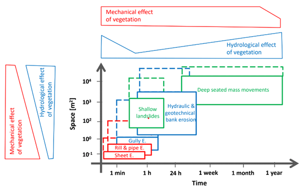
It is important to understand the spatial and temporal aspects of erosion processes if they are to be managed to reduce sediment transfer to waterways. Figure 1 shows a conceptual outline of the various processes and their relationship to the magnitude of the mechanical and hydrological effects of vegetation (one of the main ESC measures). Such an overview helps inform a strategy for choosing the best combination of measures to achieve the greatest effect at the catchment scale. This approach also highlights potential conflicting interactions; for example, drainage measures that increase slope stability may contribute to increased stream discharge regimes, leading to an increase in bank erosion.

Figure 1. A conceptual visualisation of the spatio-temporal dimensions of erosion processes triggered by hydrological events. On the top and left, the meaning of the effects of vegetation for different temporal and spatial scales are illustrated. Dashed lines indicate the extension of dimensions considering the contributing and runoff/runout zones (source: M. Schwarz).
Commonly used performance values for erosion/sediment reduction by erosion process as a result of implementing ESC practices are:
- surface erosion: wetlands, 60–80%; sediment retention ponds, 70% with chemical treatment and 30% without chemical treatment; silt fences, 99%; grass buffer strips, 40%; wheel track ripping, 90%; cover crops, 40%
- landslides: space-planted trees, 70%; afforestation or reversion, 90%
- gully erosion: space-planted trees, 70%; afforestation or reversion, 90%; debris dams, 80%
- earthflows: space-planted trees, 70%; afforestation or reversion, 90%
- bank erosion: riparian fencing and/or planting, 50%.
Any ESC practices involving trees or shrubs (afforestation, space planting, riparian or gully planting) take time to become fully effective:
- afforestation and reversion, 10 years
- space-planted trees and gully tree planting, 15 years
- riparian retirement with fencing, 2 years.
Vegetative practices (e.g. cover crops, re-grassing) used to control surface erosion require near-complete vegetation cover, but the time scales for this are likely to be shorter (up to a year). Most of the practices used for earthworks erosion management are effective immediately.
The international review team made the following suggestions for New Zealand.
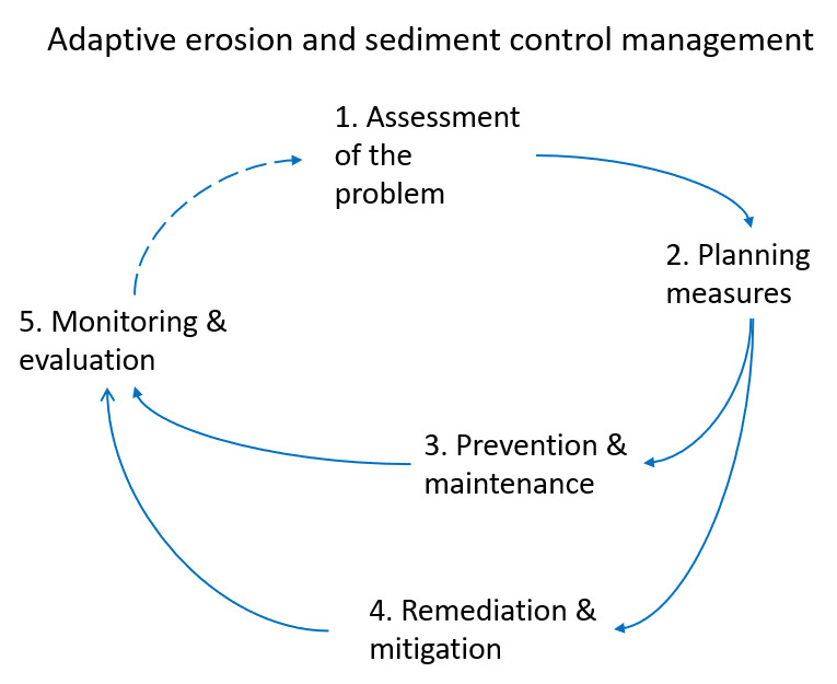
- Formulate and apply an ‘adaptive ESC management concept’ (e.g. Figure 2) as a tool to underpin effective implementation of ESC practices, to provide consistency at different administrative levels (national, regional, local).
- Develop ‘standard’ quantitative methods for assessing ESC practices.
- Build georeferenced cadasters to document mitigating measures to improve the efficiency of the management and effectiveness of ESC practices or methods, particularly if they are coupled with monitoring and evaluation methods.
- Focus more attention on evaluating the performance of ESC mitigation techniques over the long term, particularly where vegetation/trees are used.
- Apply different types of models and datasets during different management phases (assessment, planning, and evaluation) to improve the predicted effectiveness of ESC measures.
- Carry out communication, training, and dissemination of knowledge about ESC measures at the local scale (i.e. with practitioners), which is important in the planning and implementation phases.
- Put more effort into understanding the chain of processes for defining the effectiveness of ESC interventions at the catchment scale.
- Explore innovative ways to use remote sensing to assess ESC performance.
- Define and quantify the existing or potential processes (e.g. using remote sensing techniques, field measurements, model predictions), and also consult stakeholders (e.g. farmers, local population suffering from the off-site effects of soil erosion (muddy floods), civil protection services).
- Plan measures at different scales (e.g. regional plans vs farm plans), using appropriate information (e.g. modelling results).
- Apply spatial, technical or biological measures for the prevention of erosive processes and maintenance of measures (e.g. management of protective forests, restriction of forest operations).
- Apply technical or biological measures for the recovery or mitigation of erosion processes.
- Set strategies for the regular monitoring and evaluation (effectiveness and efficiency) of the implemented measures in order to perform maintenance or pass to a re-engineering phase.
Looking to the future
Research gaps and needs highlighted in both reports include:
- more data on the treatment performance of individual ESC practices generally.
- information on ESC practice performance under the full range of soil and rainfall characteristics (event sizes) and land uses in New Zealand.
- national recording of what gets done and where (georeferenced cadasters of mitigation measures) and standardisation of approaches to monitor and evaluate both performance and effectiveness over time.
- how to address scale issues, particularly in models (i.e. scaling up from understanding the performance of individual measures to understanding the overall effectiveness of these measures at the farm and catchment scale).
What this means, in practice, is that to improve how ESC mitigation measures are used to reduce erosion or capture sediment, significantly more attention needs to be paid both to understanding the future performance of individual and multiple measures and to assessing this against appropriate targets. Significantly more attention is also needed on acquiring economic data, because in many cases it may be that the cost outweighs the maximum potential benefit that could be gained if the implemented measures were all performing at their most efficient (i.e. hitting the problem with everything in the toolbox may not be enough to reach the acceptable/regulatory water quality target).
References
Basher L 2016. Erosion mitigation and prediction on cropland. Landcare Research Contract Report. 32 p.
Basher L, Moores J 2016. Erosion and sediment control in New Zealand: information gaps. Landcare Research Contract Report.
Basher L, Moores J, McLean G 2016a. Scientific basis for erosion and sediment control practices in New Zealand. Landcare Research Contract Report.
Basher L, Manderson A, McIvor I, McKergow L, Reid J 2016b. Evaluation of the Effectiveness of Conservation Planting and Farm Plans: a discussion document. Landcare Research Contract Report.
Phillips CJ, Basher L, Spiekermann R 2020. Biophysical performance of erosion and sediment control techniques in New Zealand: a review LC3761.
Schwarz M, Poesen J, Rey F, Holbling D, Phillips C 2020. Bio-physical performance of erosion and sediment control/mitigation techniques – an international comparison to common practices in New Zealand LC3891.

