- Home
- ...
- Smarter Targeting of Erosion Control (STEC)
- Smarter Targeting of Erosion Control (STEC) News
Sediment fingerprinting: a catchment-based technique to quantify erosion source contributions to downstream sediments
The technique involves characterising erosion sources based on field sampling, tracer selection, and source discrimination. Tracers may include a range of physical and chemical properties of soils and sediments, such as bulk geochemical, fallout radionuclide, and magnetic properties that differentiate the target sources. The next step focuses on source apportionment. This requires sampling suspended or deposited sediment downstream. Statistical mixing models are then used to estimate the proportional contribution of the sources to sediment, with associated uncertainties.
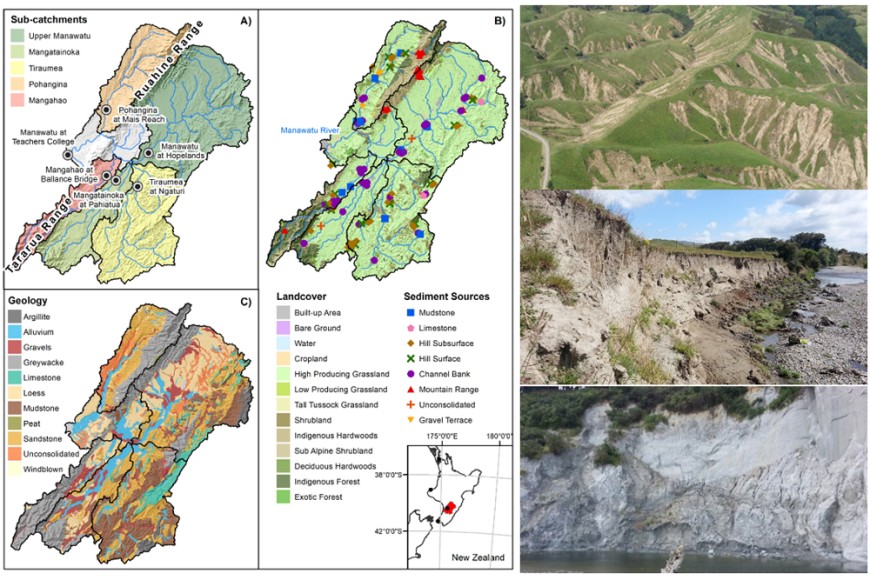
Researchers at Manaaki Whenua – Landcare Research are recognised internationally for their expertise in sediment fingerprinting and have published extensively on the technique (see Appendix). Sediment fingerprinting studies have been completed, or are underway, in the Manawatū, Oroua, Ōreti, Tiraumea, Aroaro, and upper Mōtū catchments, which include work for Horizons Regional Council and Gisborne District Council. These studies focus on determining the contribution from sources defined by different erosion processes and parent materials (Figure 1).

Figure 1. Erosion source characterisation for the Manawatū catchment. (Source: Vale et al. 2016)
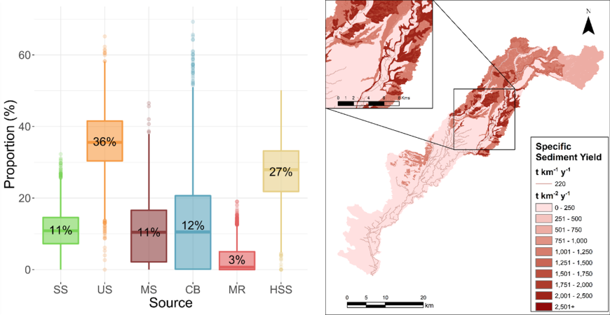
Sediment fingerprinting can provide land and water managers with unique information on where sediment is coming from in a catchment, based on direct measurements over a range of spatial and temporal scales. Instream sediment sampling may include the collection of discrete samples across the event hydrograph (Vale et al. 2020), or time-integrated samples over (typically) monthly intervals (Smith et al. 2018). Alternatively, overbank deposits can be collected in the absence of event sampling (Vale et al. 2021) (Figure 2). This information can be used to prioritise specific erosion processes or areas within a catchment for erosion mitigation to ensure interventions are targeted at those sources contributing the most sediment.

Figure 2. Estimated proportional source contributions for the Oroua catchment. SS: surface soil, US: unconsolidated sand and siltstone, MS: mudstone, CB: channel bank, MR: mountain range, HSS: hill subsoil. (Source: Vale et al. 2021)
References
Smith HG, Karam DS, Lennard AT 2018. Evaluating tracer selection for catchment sediment fingerprinting. Journal of Soils and Sediments 18: 3005‒3019.
Vale SS, Fuller IC, Procter JN, Basher LR, Dymond JR 2020. Storm event sediment fingerprinting for temporal and spatial sediment source tracing. Hydrological Processes 34(15): 3370–3386.
Vale SS, Fuller IC, Procter JN, Basher LR, Smith IE 2016. Characterization and quantification of suspended sediment sources to the Manawatu River, New Zealand. Science of the Total Environment 543(Pt A): 171–186.
Vale SS, Smith HG, Matthews A, Boyte S 2021. Determining sediment source contributions to overbank deposits within stopbanks in the Oroua River, New Zealand, using sediment fingerprinting. Journal of Hydrology (NZ) 59(2): 147‒172.

