Project co-leads Dr Chris Phillips and Dr Hugh Smith say the research has significantly improved the understanding of the complex array of erosion processes, including the economic impact of erosion and sediment mitigation. “As severe storms and significant weather events continue to increase in New Zealand, so does the amount of erosion. Recent extreme weather has re-focused attention on landslide-triggering events and approaches for better targeting erosion control to reduce damage to land and water environments from excess sediment,” says Chris.
Manaaki Whenua erosion researchers partnered with regional councils, iwi, and international and New Zealand agencies and universities during the programme. Many of the studies have put Manaaki Whenua at the forefront of global research to understand how to best target erosion control.

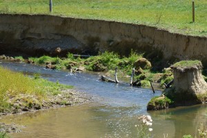
Exposed fence posts left behind after a hill slumps away.
A key area of research focus was on rainfall-induced shallow landslides. This included work to automate the mapping of landslides using high-resolution satellite imagery with the landslide data used to model landslide susceptibility with LiDAR-derived digital elevation models (DEMs). The resulting high-resolution landslide susceptibility maps are informing land-use planning and allowing improved targeting of tree planting for erosion control. This research is also helping our understanding and future management of the ‘window of vulnerability’ following harvesting in steepland plantation forests.
Similar data-driven approaches to modelling the likelihood of shallow landslides delivering sediment to streams have also been developed. These models represent the spatial probability of ‘landslide-to-stream’ connectivity and provide new, high-resolution insight into those specific areas most likely to produce landslides and deliver sediment to streams.
Hawke’s Bay Regional Council is already using high-resolution shallow landslide susceptibility layers produced by STEC research following Cyclone Gabrielle. Equivalent landslide susceptibility layers were also produced for Tairāwhiti and shared with Gisborne District Council, MPI and forestry companies following the cyclone.
The work on sediment source fingerprinting spanned multiple applications of the technique to support improved targeting of erosion control to reduce downstream sedimentation (see Fingerprints point to the sediment source). There was also a four-year study of the movement rates for a large earthflow located in the Haunui research catchment, a headwater tributary of the Manawatū River (see Me ora te ngahere: forest health through an indigenous biocultural lens). This work aims to help us better understand the hydroclimatic conditions that drive variations in the rates of sediment delivery to streams from these large, slow-moving landslides.
Chris says the programme has delivered several firsts, including data-driven modelling that represents the influence of individual trees on landslide susceptibility and a new New Zealand landslide susceptibility model that incorporates ground-based weather radar data on rainfall intensities.
He says it’s been satisfying to complete the programme seeing increased awareness and confidence among collaborating regional councils to target their erosion control investments towards meeting catchment targets for sediment. “We’ve seen a more holistic understanding of New Zealand’s erosion-sediment and water quality problem particularly among regional and central government agencies.”
“With better data, and better models that allow us to actually link erosion on the land to instream related water quality impacts it enables us to better inform managers when it comes to deciding where to target their investment in erosion control to maximise the benefits downstream,” says Hugh.
“Iwi partners are using new knowledge of landslide susceptibility in the Whanganui catchment while several regional councils are routinely using improved sediment modelling tools to implement National Objectives Framework sediment targets and assess outcomes under future erosion mitigation and climate change scenarios.”