It’s only recently that Manaaki Whenua researchers have been able to quantify one of the biggest threats to the existence and function of wetlands: drainage. Drains have historically been seen as an intrinsic component of land management in New Zealand, resulting in extensive construction of drainage systems across the country. This has decreased the natural extent of wetlands by around 90% since human arrival in New Zealand.
While recent regulations restrict new drainage close to wetlands, the national extent of existing drainage in or near wetlands is unclear. The first step Manaaki Whenua researchers took was to use the existing LINZ national drains spatial layer, to assess where known drains occur near wetlands. However, the national drains layer was not designed to delimit drains for ecological purposes. So, the team looked to a new source of data, using LiDAR, which detects very small changes in elevation, such as those caused by drains.
By using LiDAR for this purpose, ecologist Dr Olivia Burge says researchers can get a better assessment of the area of wetlands within 100m of drains. In research published in the New Zealand Journal of Ecology, Olivia says not only does this work help to identify where the potential risks from drainage exist, it has the potential to be scaled-up nationally as LiDAR coverage increases to complement the mapping of wetlands down to 0.05ha, which is required to be completed by 2030.

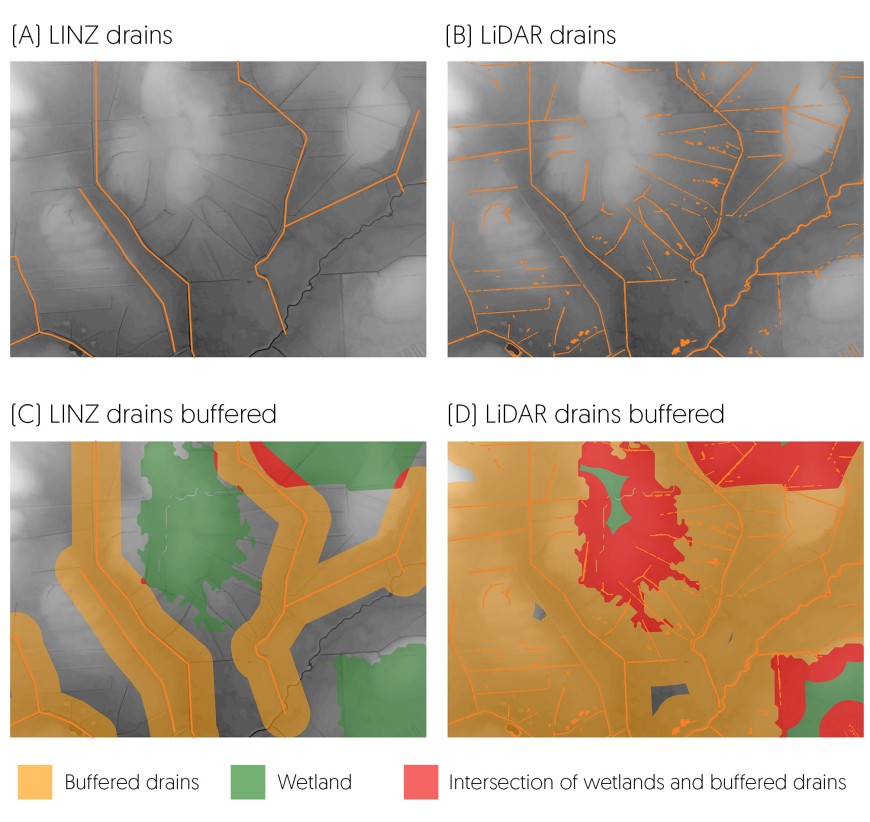
(A) LINZ drain coverage, clearly showing many drains missing. (B) LiDAR drain coverage with some drains missing, but also a river channel mapped as a drain. (C) LINZ drain coverage buffered by 100 m, showing a small overlap between drains and wetlands. (D) LiDAR drain coverage buffered by 100 m, showing substantial overlap (red) between areas mapped as wetland by FENZ, and the buffered drains. Note little wetland left in green (i.e. not within 100 m of a drain) in this image.
Co-author Dr Janet Wilmshurst, also from Manaaki Whenua, adds “this is good news for small wetlands which are disproportionally important in conserving biodiversity but are currently too small to be mapped. As LiDAR coverage becomes more widely available, this technique will be able to better assess the risks from drainage to all wetland habitats regardless of size over New Zealand and help to safeguard the future of these ecologically important and vulnerable ecosystems.”
Paper co-author Dr Hugh Robertson, a wetland ecologist from the Department of Conservation, says they developed a LiDAR-informed model to identify drains, which they then compared with the national drains spatial layer. Both layers were applied to the Waituna catchment in Southland to determine how effective the LiDAR-informed model might be at detecting previously undetected drains, and, therefore, how much more wetland was at risk of drainage-related impacts.
“LiDAR showed the area of wetlands potentially affected by drains is more extensive than the national layer might suggest,” says Hugh.
Olivia is also using LiDAR combined with recent improvements to soils mapping in S-map, to improve pre-human wetland extent mapping.
“The historical wetlands layer is critical for understanding and reporting on wetland loss through human activities in New Zealand, including which wetland types have been lost, and where has suffered the most loss,” says Olivia.
However, the historical wetlands layer was developed in the 2000s, and relied heavily on now-outdated soils and digital elevation model information. “Fewer wetlands in a catchment increase flooding risk in extreme events, and as such revising the layer is particularly topical to address flood risk.”
LiDAR technology is proving to be a useful tool to help safeguard the future of these ecologically important and vulnerable ecosystems.
