As the clean-up continues it is becoming clear that much of the landscape in the worst-affected areas has effectively been ‘reset’ by Gabrielle. It has affected substantial areas of natural and regenerating ecosystems, productive land (including farm, orchard, forestry, and vineyard operations), much vital infrastructure, and many rural and urban settlements.
Manaaki Whenua will have significant immediate and long-term contributions to make to the recovery from the cyclone. One of the most urgent early research responses is to update vital satellite, LiDAR, and optical imagery to discover exactly how landscapes and catchments have changed.
As part of this early response we have made available our expertise in big data analysis and interpretation to support ministries and agencies such as regional and local councils that have an immediate role to play. This work includes assisting GNS Science’s response to the cyclone focused on mapping landslides from high-resolution satellite imagery.
We were already involved with a project with Hawke’s Bay Regional Council to map landslides following a heavy rainfall event in March 2022. The new regional LiDAR will be used to update our data on landslide susceptibility, landslide-debris mapping, erosion mapping, land characterisation, cultural mapping, and vegetation cover mapping. As initial response gives way to longer-term recovery, Manaaki Whenua will draw on a large body of integrated research knowledge and data that encompass economic, social, environmental, cultural, and policymaking aspects to ensure relevant, resilience-building research.
We have a current Ministry of Business, Innovation and Employment (MBIE) Endeavour research programme of direct relevance to the devastating soil loss and silt deposition caused by Gabrielle. ‘Smarter Targeting of Erosion Control’ (STEC), now in its final year, is a pivotal research programme that has significantly improved understanding of spatial and temporal patterns of soil erosion, sediment-related water quality, sediment mitigation, and modelling. The most recent STEC outputs include high-resolution geospatial modelling of shallow landslide susceptibility to better inform targeting of mitigation measures, catchment-based sediment ‘fingerprinting’ (determining where eroded sediments originated), understanding the sediment contributions of large, slow-moving landslides, and modelling the likely patterns of soil erosion and sediment transport under future climate change (see below).
Led by Manaaki Whenua researchers Dr Chris Phillips and Dr Hugh Smith, STEC includes researchers from NIWA, Massey and Canterbury Universities, and international collaborators from KU Leuven, INRAE, University of Salzburg, and Bern University of Applied Sciences in Switzerland. Our partners include Whanganui iwi (Tamaūpoko Community Led Trust) and Rangitāne o Manawatū. STEC has been supported throughout by Northland, Waikato, Horizons, and Hawke’s Bay Regional Councils, Auckland Council, Environment Southland, the Ministry for the Environment, the Ministry for Primary Industries, Our Land & Water National Science Challenge, and Federated Farmers.
We offer research expertise in forestry slash management, weed management (weeds may spread onto newly exposed soils), and in wildlife, plant population, and disease modelling as the affected areas recover. Our mapping capabilities will be needed to assess changes in the landscape’s carbon stocks through loss of woody vegetation and carbon-rich soil.
In another relevant Endeavour research programme, we are working to understand whether biomass and soil carbon stocks in rural landscapes can be enhanced by the planting or natural regeneration of small clusters of trees, matched with soil and climate conditions.
Our social scientists are also well positioned to help build back better after Gabrielle. We can help to analyse the social and economic impacts of the cyclone, including how change is managed and the inter-related, intergenerational resilience of communities, economies, and biodiversity.
In two Endeavour-funded social research programmes already underway, we are unlocking effective decision-making for land managers, and seeking to identify and demonstrate how kaitiakitanga practices (which might include economic opportunities) achieve biodiversity regeneration, cultural revitalisation, and community well-being.
With soils across much of the North Island already saturated from an unusually wet summer, including Cyclone Hale a few weeks earlier, the rapid, unrelenting rainfall of Gabrielle could not be absorbed. The saturated soils triggered shallow landslides in the steep, erodible hill country, displacing millions of tonnes of sediment across a range of land uses – pastoral farming, plantation forestry, native forest, and native scrub. The worst-hit areas were the Hawke’s Bay and Gisborne regions.
Gabrielle by the numbers
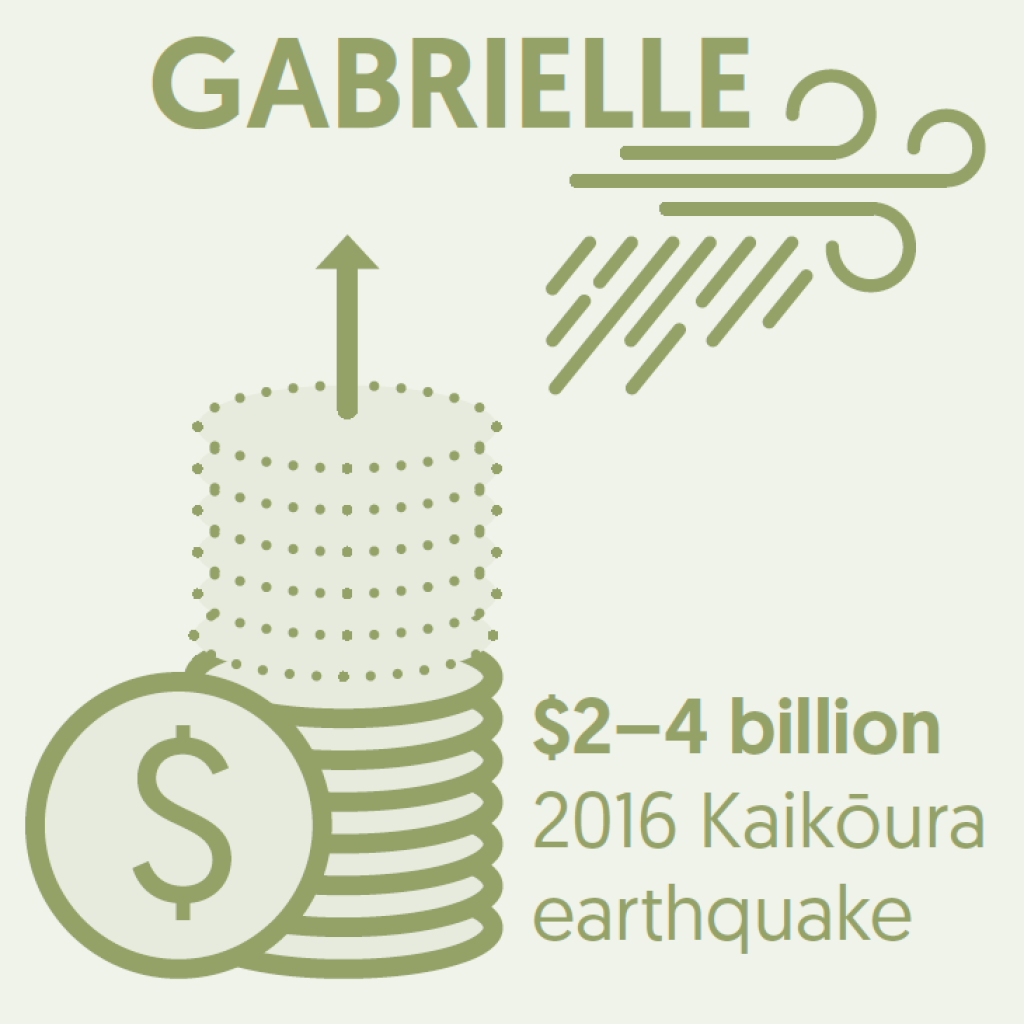
According to the Ministry of Foreign Affairs and Trade, Cyclone Gabrielle was New Zealand’s costliest non-earthquake natural disaster to date, with economic losses currently expected to exceed the $2 billion to $4 billion losses of the 2016 Kaikōura earthquake. It was also the deadliest since Cyclone Giselle in 1968.

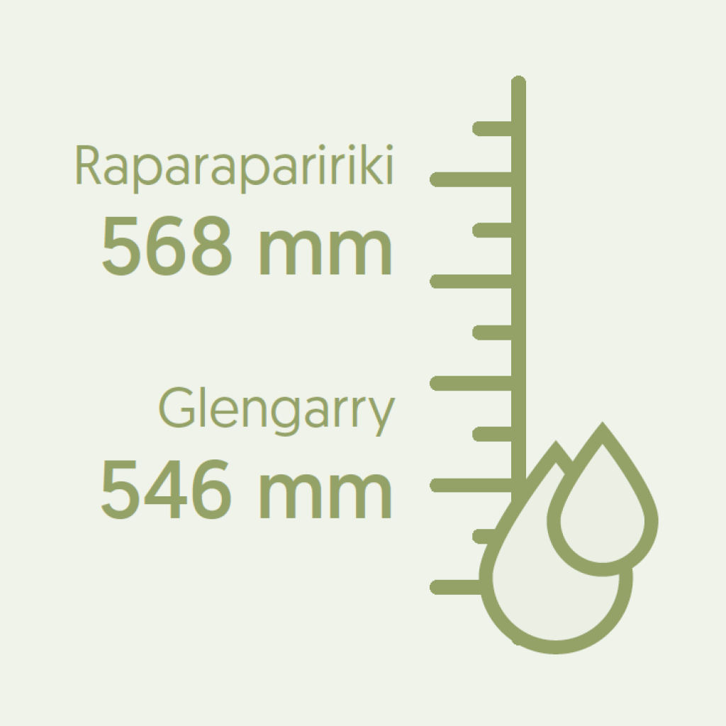
Weather station data showed that, in places, Gabrielle also brought record rainfall intensities. In the Pōrangahau catchment monitored by Hawke’s Bay Regional Council, twice as much rain fell during the most intense 24-hour rainfall period of Gabrielle than during the most intense 24-hour period of Cyclone Bola in 1988. Huge rainfall totals were also recorded elsewhere in the region: Glengarry, near Napier, had 546 mm of rain, 400 mm of which fell in just 12 hours, and 568 mm fell at Raparapaririki in the ranges of Gisborne. NIWA reported that during Gabrielle, Whangārei had its wettest February day on record and Napier its second wettest.
A tool for solving landscape-scale problems
LUMASS – the Land Use Management Support System developed by Manaaki Whenua – is a data-driven decision-support tool that allows complex land-use planning problems, such as those created by the large-scale landscape modifications of Cyclone Gabrielle, to be mapped and solved.
By integrating data from different science domains, LUMASS enables stakeholders such as regional or local councils to run scenarios to define optimum land-uses at a variety of scales (a landscape, a catchment, a whole region). Desirable outcomes, constraints and trade-offs can be specified, for example the aim of minimising greenhouse gas emissions, or meeting National Policy Statement guidelines for fresh water, or to identify areas suitable for specific agricultural uses.
Current work with LUMASS explores its use for developing climate change adaptation pathways.
River catchment planning for future climate change
To develop effective management plans for river catchments, policymakers and catchment managers need to account for how climate change might affect soil erosion and river sediment loads. However, there has been no published, quantitative assessment of national-scale changes in erosion or suspended sediment loads anticipated under future climate for Aotearoa New Zealand.
To address this gap, Manaaki Whenua’s Dr Andrew Neverman and colleagues, in collaboration with AgResearch and NIWA and with funding from the Our Land and Water National Science Challenge’s Whitiwhiti Ora programme, have produced Aotearoa New Zealand’s first national assessment of the potential impact of climate change on erosion and suspended sediment loads.
As part of the project, future erosion and sediment loads were estimated for mid-century (2040) and late century (2090) based on projected changes in climate and hydrology. Changes in suspended sediment loads were modelled under four potential future atmospheric CO2 concentrations, with associated changes in rainfall intensities and amounts.
The results of this modelling, published in the international journal Geomorphology, show that up to 28% of the North Island and 8% of the South Island are estimated to experience a two-fold or greater increase in average annual sediment supplied to the channel network by late century.
Exploring the impacts of climate change on Māori
In October 2021, Ngā Pae o te Māramatanga and Manaaki Whenua released a report offering new guidance for te ao Māori on climate change adaptation and mitigation. He Huringa Āhuarangi, he Huringa Ao: A Changing Climate, a Changing World was produced by a multidisciplinary Māori research team working across many research institutions and led by Manaaki Whenua’s Dr Shaun Awatere.
Using a novel kaupapa Māori risk assessment approach to climate change, the report synthesised the latest climate change research through a Māori lens, and identified the potential impacts, implications, mitigation and adaptation strategies for whānau, hapū, iwi, and Māori business.
He Huringa Āhuarangi, he Huringa Ao predicts that Māori well-being across all four key domains – environment, Māori enterprise, healthy people, and Māori culture – will be moderately affected by 2050. By 2100 the risks to ecosystems are likely to show severe impact, compromising many aspects of Māori well-being.
Further developments in incorporating a Māori world view into issues of climate change are discussed in the article Māori frameworks needed to recloak the whenua.
Key contact