How many landslides were prevented during Cyclone Gabrielle?
Scientists at the Bioeconomy Science Institute, working alongside Hawke’s Bay Regional Council, studied 50 farms in the Hawke’s Bay region that experienced intense rainfall during Gabrielle but had varying levels of landsliding. Using data generated from high-resolution LiDAR-derived elevation models and aerial imagery, the researchers modelled two scenarios for Cyclone Gabrielle on the pastoral areas of each farm. The first was the ‘real’ scenario, representing the landscape with its existing trees. The second was a ‘what if’ scenario, where they modelled removal of all trees from pasture areas to see what could have happened without them.
The models estimated that existing trees on these 50 farms prevented an extra 1,865 landslides from occurring (a reduction of 8.4%), equivalent to an estimated 230,000 tonnes of soil. In other words, the presence of trees provided meaningful, quantifiable protection against landslide damage during Cyclone Gabrielle.

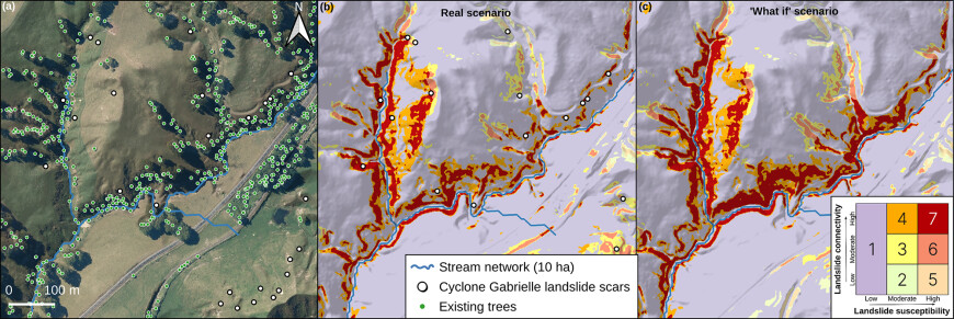
The influence of individual trees on the spatial extent of areas highly susceptible to landslide occurrence and connectivity to streams: (a) satellite imagery of a pastoral area, showing the location of existing trees and mapped landslide scars after Cyclone Gabrielle; (b) modelled shallow landslide susceptibility and connectivity for the ‘real’ scenario (i.e. with existing trees); (c) modelled shallow landslide susceptibility and connectivity for the ‘what if’ scenario (i.e. with trees removed). Note the reduction in class 4 and 7 (high and moderate landslide susceptibility and high connectivity) areas from (c) to (b) along the watercourse.
The study also estimated the reduction in sediment reaching the stream network. Across all 50 farms, existing tree cover led to a 9% reduction in the amount of landslide-derived sediment that could have been delivered to streams, equating to approximately 16,150 tonnes of sediment. On some farms the proportional reduction was up to 24%. However, we estimated the median reduction across all farms to be 10%, with some showing a marginal reduction of 2–4% due to the limited extent or suboptimal location of trees for landslide mitigation.
The influence of individual trees on the spatial extent of areas highly susceptible to landslide occurrence and connectivity to streams: (a) satellite imagery of a pastoral area, showing the location of existing trees and mapped landslide scars after Cyclone Gabrielle; (b) modelled shallow landslide susceptibility and connectivity for the ‘real’ scenario (i.e. with existing trees); (c) modelled shallow landslide susceptibility and connectivity for the ‘what if’ scenario (i.e. with trees removed). Note the reduction in class 4 and 7 (high and moderate landslide susceptibility and high connectivity) areas from (c) to (b) along the watercourse.
This study demonstrates the benefit of trees for building resilience in our landscapes to rainfall-triggered landslides, and shows the value of mitigations implemented to date, with existing trees in the Hawke’s Bay region already providing a meaningful reduction in erosion and sediment delivery to streams.
The research highlighted that the effectiveness of trees is not just about how many there are, but also where they’re planted. The biggest reductions in soil loss and sediment delivery were seen on farms where trees were located in the most vulnerable areas, and where landslides have a high probability of reaching the stream network, highlighting the importance of targeted mitigation efforts.
The detailed shallow landslide susceptibility and connectivity maps can be used to target future tree planting to the most landslide-prone areas. This will provide a more effective approach to protecting our soil, the productive capacity of our farms, and the health of our water resources from future storm events.
Key contact

