Skull
An important phase of any pest eradication programme is surveillance to try to find any survivors. This can be done using a variety of methods, including trail cameras, tracking tunnels and/or bite-mark devices (e.g. WaxTags® or chew cards). If there is evidence of survivors, then eradication has been unsuccessful and cannot be declared. This decision may lead to mop-up control, total recontrol, or reassessment of the feasibility of control.
If, however, there is no evidence of survivors, then the conclusion is less certain. The targeted species may have been successfully eradicated, but it is also possible that surviving animals are present but not detected. What, then, is the decision if there are no detections? Is the species absent or not?
The conclusion ultimately depends on the answers to three questions:
- How confident in eradication were managers before undertaking surveillance?
- How hard did managers look for any pests that may have survived the eradication programme?
- How confident do managers want to be when declaring eradication?
These three factors can be related by an equation called Bayes’ theorem: 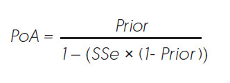
The ‘Prior’ is the probability that eradication was successful before any surveillance was carried out and reflects how good the control programme was thought to be. This may be based on expert knowledge, outcomes of similar eradications, simulation modelling, or some combination of these factors.
The system-level sensitivity (SSe) is the probability of detecting the species if it is still present, and reflects how good the detection network is at finding pests. This is calculated from the spatial arrangement of devices, how long they have been deployed, how good they are at detecting the species, and its home range size.
Bayes’ theorem therefore updates prior knowledge (Prior) with data (SSe) to give the posterior probability of absence (PoA). PoA increases with more surveillance, as long as no targeted pests are detected during surveillance: if they are, then eradication was unsuccessful and PoA = 0.
Depending on the value of PoA, a management decision is made to declare the species absent and eradication a success, or to carry out more surveillance (i.e. increase the overall SSe until a value of PoA is reached that the manager is happy with). Because managers can never be 100% sure of success, the target value for declaration of eradication is set to reflect an acceptable failure rate: too low and managers risk incorrectly declaring success and having to incur expensive recontrol or loss of support; too high and managers will have overspent on unnecessary surveillance.
This PoA framework was developed by Dean Anderson and others for OSPRI to process surveillance data used to help make decisions about declaring areas free of bovine TB. It has more recently been modified by Dean to help make decisions about attempts to eradicate invasive species.
An example of a tracking card.
Predator Free 2050 in New Zealand and the Centre for Invasive Species Solutions in Australia (CISS) were keen to make the surveillance framework easier to use, and so they funded the development of a tool to allow managers to process their surveillance information consistently. Audrey Lustig, working with Pascal Omondiagbe from the Informatics team at Manaaki Whenua, embedded Dean’s framework in a web-based user platform.
A two-day user workshop was held in October 2019 and hosted by Manaaki Whenua researchers from the newly formed Centre for Applied Ecological Modelling (CAEM). Twenty-five participants attended from Predator Free 2050, CISS, HBRC, Taranaki Regional Council, Predator Free Dunedin, Predator Free Wellington, and Biosecurity Queensland.
On day one the principles of surveillance to prove absence were presented, covering topics such as how to specify a Prior, calculating surveillance sensitivity, and how to know when to declare success. This was followed on day two by user testing of the PoA software with their own surveillance data, as well as a demonstration of the JESS4Pests app, which is used for calculating how much surveillance is required (see https://landcareshinyapps.io/JESS4Pests).
The workshop was a great opportunity to ensure the software met the needs of the end-users, as well as providing the end-users with the information required to understand the process and framework. As a result of the workshop, the PoA software will be further refined to add more functionality.
Feedback was overwhelmingly positive, with one manager stating that
We got a lot of value from better understanding the model, its parameter inter-relationships and the operational implications of these. In addition, we were able to run the model with our data which gave us some really valuable operational and risk insights and will lead to changes in what we are doing. The discussion on the model helped us change our thinking on how we are framing the results around eradication, PoA etc for our stakeholders and community. Finally we were able to wrap up by exploring some of the real life challenges we have around eradication, PoA, risk and operational expenditure. With the collective science / research-based expertise we charted some useful solutions to future challenges we may face.
This process of development and engagement is a great demonstration of the benefits of working closely with stakeholders and end-users to ensure outputs are tailored to their needs and to help them deliver their outcomes.
This work was supported by Strategic Science Investment Funding from the New Zealand Ministry of Business, Innovation and Employment, the Centre For invasive Species Solutions, Australia, and Predator Free 2050.
Key contacts
Andrew Gormley

Dean Anderson