New water retention model in S-map
In recent years S-map has relied on a WRC pedotransfer function developed in 2014. MBIE Endeavour research programme funding has enabled this model to be updated. Over the last 3 years, a major effort has been made to substantially increase the amount of measured data from which the model is derived. Data from 293 legacy sites were ‘rescued’ from hardcopy reports and excel spreadsheets and uploaded into the National Soil Data Repository after a quality control process. An additional 166 new sites were sampled across the country, bringing the total number of sites to 684, more than double the number used in the development of the 2014 model.
To develop the new pedotransfer function, a beta regression model was found to be the best statistical modelling approach, as described in McNeill et al. (2018). After an iterative process of model building and testing of the extrapolated results, the team have finalised the model and implemented it in the S-map inference engine. The increase in measured data has resulted in a significantly more robust model. Ten percent (838) of soil siblings were not able to be predicted using the 2014 model as the estimate of the prediction error indicated they were too unreliable. Just four siblings are too uncertain in the 2020 model.

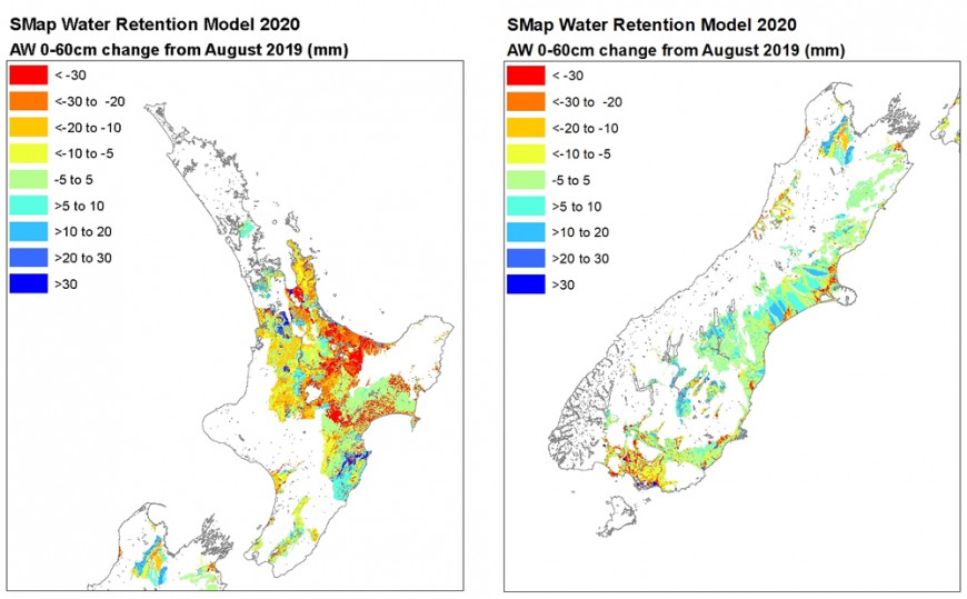
Figure 1: Difference in estimates of PAW to 60 cm from the new water retention model and previous estimates.
Because the S-map pedotransfer functions are national models, the release of a new model means that all soils in S-map can potentially have a change in the predicted attribute values. In the new 2020 model the estimates of PAW have in general gone down for siblings from the Allophanic, Gley, Pumice, Recent, and Ultic soil orders of the New Zealand Soil Classification, with increased PAW for Granular and Semiarid soils. Figure 1 shows the spatial changes in PAW for the soil profile down to 60-cm depth. The impact of the new soil moisture information has been tested in OverseerFM by comparing the nutrient loss results from 32,000 farms. Of these, the Overseer team report that 71% have a change in estimated nitrogen losses of less than ± 10%, but 8% will see an increase of more than 20% of the estimated nitrogen loss/ha.
The new model also includes the results of some PhD work that investigated the water-holding capacity of stones. One area where more data and research are still needed is pumice soils and lapilli. Associated research on combining farm-based measurements with S-map models is underway.
The new estimates of the key soil moisture properties including PAW (also known as water-holding capacity) were released in August 2020. These improved estimates are important for helping New Zealanders achieve environmental and economic outcomes from their land. In particular, more accurate soil moisture information will lead to better knowledge of irrigation demand and nutrient losses.
Funding
MBIE, Fertiliser Association of New Zealand, as well as Waikato, Hawke’s Bay, Wellington, Tasman, Marlborough, Canterbury and Southland Regional Councils.
Further reading
McNeill S, Lilburne L, Carrick S, Webb T, Cuthill T 2018. Pedotransfer functions for the soil water characteristics of New Zealand soils using S-map information. Geoderma 326: 96–110, DOI: 10.1016/j.geoderma.2018.04.011.
Key contacts


