Advances in wireless sensor network communications – using garage-door remotes in the 1990s to satellites in 2021
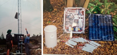
Figure 1: Single data station. A nest of tensiometers to measure soil water status, rain gauge, solar back-up and radio for data telemetry (1989–1992).
The dataloggers themselves were very expensive, power-hungry machines, and most datalogging systems were single-station, multi-sensor arrays (Fig. 1). Frequent site visits were required to collect the recorded data as they were not telemetered. Since the 1980s, Manaaki Whenua – Landcare Research has pioneered research into automated measurement and collection of soil moisture and environmental data. Back in the late 1990s, the lack of commercially available wireless datalogging equipment encouraged us to develop our own wireless dataloggers using remote controlled garage-door openers – the only low-power wireless communicators available around that time (Fig. 2). A joint project with Oregon State University, USA, gave us the opportunity to design and test the first garage-door remote controlled wireless sensor network in the H.J. Andrews experimental forest in Oregon, in 2001.
In the early 2000s, low-power single- and multi-channel stand-alone dataloggers became available, which enabled more reliable measurement and collection of soil hydraulic and environmental data. However, near real-time data to support precision irrigation scheduling were not yet available for farmers, because frequent visits to the datalogger sites were still needed to retrieve data that then needed further processing to provide the required information.
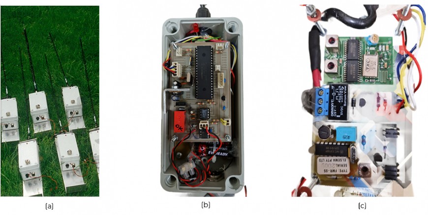
Figure 2 (a) Wireless sensor nodes with two live nodes (1996–2000), (b) wireless sensor node, (c) remote garage-door opener as wireless link with ~100-m range.
Further technological advances eventually enabled the data from stand-alone dataloggers installed into different soil zones on a farm to be gathered from a single point in the field and made available on smartphones via cellular networks or satellites. This is the concept behind modern wireless sensor networks (WSN), which have a ‘gateway’ (physical device or software programme) that acts as a data-relaying point to cloud storage and databases where data are processed into spatial information, for example, of soil water status. Being able to visualise data in real time, farmers use these tools for precision irrigation scheduling to increase their water use efficiency.
Advances in low power digital radio technology operating in license-free frequency bands allowed the subsequent development of commercial WSN products such as ZigBee, XBee, Crossbow, and DigiMesh. Other examples of the use of these systems to form WSN to measure soil hydraulic properties in real time are available in the further reading at the end of this article; see also Figure 3 for an example of their output.
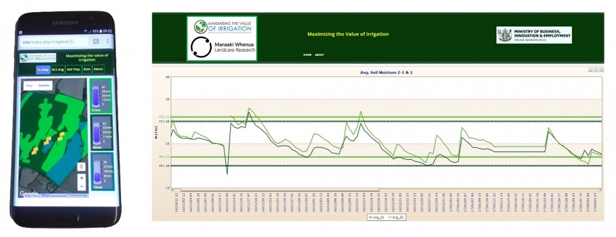
Figure 3: Near real-time soil moisture data visualisation with control lines to indicate when to irrigate and when to stop.
The breakthrough in terms of power efficiency and range was the birth of LoRa radio technology. In 2019, as part of a Manaaki Whenua – Landcare Research project on regenerative agriculture in hill country landscapes, we were able to expand the area over which we could measure soil moisture and temperature from ~5 km2 with DigiMesh to over 200 km2 using LoRa radio technology.
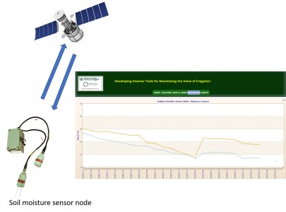
Figure 4: Soil moisture data from two depths uploading to the cloud via Iridium satellites for near real-time data visualisation.
Use of a cloud-based gateway connected to a cellular network has solved most of the problems associated with near real-time data collection. However, one major hurdle remained until recently: the limited cellular service coverage in rural areas of New Zealand. This problem was eliminated in 2020–21 by using satellites for bi-directional data communication. There are several satellite systems available for this purpose, but the Iridium satellite system is probably the best: there are 66 Iridium satellites orbiting the earth, giving coverage of the entire planet around the clock (Fig. 4).
Technological advances over the last 30–40 years have advanced wireless sensor networks so that they are now able to provide current high-resolution information on soil moisture and other environmental parameters – which was previously the missing link for rapid and effective strategic decisions by land managers.

