The stories on our stand include:
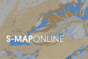
- S-map Online - More than a map
- Trees in landscapes - Can small clusters of trees add value to rural landscapes?
- Smarter targeting of erosion control - Getting the dirt on erosion
- The future of tree mapping in rural and urban environments
- Survey of Rural Decision Makers - Make sure your voice is heard
More than a map
S-map is a digital soil map of Aotearoa New Zealand that provides soil information on more than 5,500 different soil types that have been mapped so far. You can access the data through the S-map Online portal.
Using S-map Online you can:
- Explore interactive soil maps of Aotearoa New Zealand
- Learn about soils in your area
- Browse, view and download a variety of soil fact sheets
- Identify and compare soil siblings - the most detailed level of soil classification
- Create custom soil maps for printing
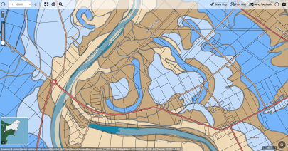
Example of soil drainage layer in Makaraka, Gisborne.
Data are generated by expert soil surveyors, assisted by historical soil mapping and innovative new data sources as part of an ongoing national initiative through a coordinated partnership with the Ministry for Primary Industries, Ministry for the Environment and 13 regional councils.
More than 10 million hectares of Aotearoa New Zealand have been mapped, with half a million hectares added every year to the database.
You can access this information through S-map Online. It’s easy to use, just enter your address and take a look at the soil types where you live.
For more information, contact Sam Carrick or Linda Lilburne.
Related links
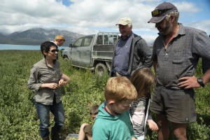
Can small clusters of trees add value to rural landscapes?
We are leading a five year programme looking at the benefits of increasing biomass and soil carbon stocks from clusters of trees established in pasture as an alternative to plantation forest.
The Trees in Landscapes programme, led by David Whitehead and Sam McNally, is focusing on enhanced carbon stocks around the edges of tree clusters compared with the same land area of plantation forest with a number of additional co-benefits for landowners:
- Provide shelter and food for animals
- Reduce nitrate leaching
- Reduce erosion by holding hillsides together
- Improve productivity
- Maintain rural livelihoods
- Aligns with te ao Māori world views.
Can you help our researchers?
 The programme is looking to recruit 32 farms to obtain baseline data to test the idea that there are carbon and biomass benefits around clusters of trees.
We have strict criteria for site selection:
- Blocks or belts of trees alongside grazed pasture
- Can be fenced or unfenced
- Land cannot be too steep (less than 20 degrees)
- Tree clusters must be at least 20 meters wide
- Trees must be at least 7 years old
- Can be any species.
Once a farm has been selected, our research staff will be on site for 2-3 days taking soil samples and doing lots of measurements around the tree clusters. No destructive work will take place and the site will be left in the same condition as it started in.
From there, four sites will be selected that will have regular seasonal visits over the next four years for more detailed measurements. Any findings from individual farms can be shared back with the landowners. No reference to their location or identity will be made publicly available.
Please contact David Whitehead if you would like more information on the trial.
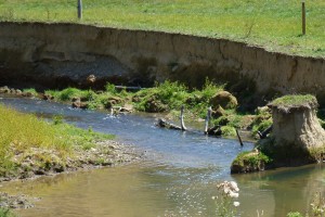
Getting the dirt on erosion
 Erosion in New Zealand has many social and economic impacts, such as reduced soil fertility and productivity, decreased carbon sequestration, sediment impacts in water bodies, and damage to properties and infrastructure.
Smarter Targeting of Erosion Control (STEC) is a 5-year collaborative research programme funded by the Ministry of Business, Innovation and Employment, and led by Manaaki Whenua to look at what type of sediments are produced by which erosion processes, and then ways to reduce erosion damage.
The models created from STEC indicate how sediment – in particular, fine sediment – moves through catchments. Our researchers are looking for the most cost-effective way to get erosion control to where it will have the greatest impact.
The project aimed to:
- link erosion on the land to sediment transport and instream water quality,
- determine a catchment’s status with respect to meeting national water quality standard,
- ultimately enable more cost-effective and smarter targeting of erosion mitigation to prevent sediment issues downstream.
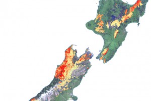
Shallow landslide susceptibility
Tree species mapping in pastoral hill-country to compare landslide susceptibility of rural sites.
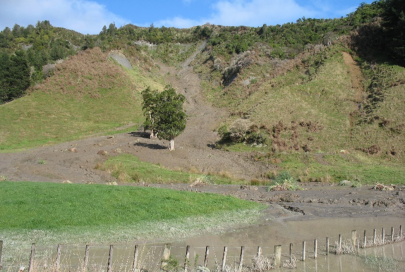
High-magnitude rainfall events that trigger hundreds to thousands of shallow landslides in New Zealand’s hill country are associated with significant costs in terms of damage to land and infrastructure, agricultural losses, and impacts on freshwater environments. Landslide susceptibility analysis provides a measure of the relative likelihood of a landslide occurring based on landscape conditions. This information can then be used to better inform targeting of erosion control measures.
The STEC team has used remote sensing methods to improve the modelling risk of landslide susceptibility. The use of this technology has enabled the assessment of quantifying how effective trees are at reducing landslide erosion and sediment loss at a range of spatial scales.
If you would like to discuss the STEC programme in more detail, please contact Chris Phillips or Hugh Smith.
Related links
The future of tree mapping
An example of tree mapping using LiDAR.
Trees provide many benefits for our environment:
- Carbon sequestration
- Climate regulation
- Reduce soil erosion
- Habitat for native species.
There is a clear need to develop better tools that map, model and manage individual trees in different environments.
We use various Artificial Intelligence (AI) technologies and apply them to any type of imagery we work with that include hi-res aerial photos, remotely sensed images from a satellite, or raster-based images. The programs we use require accurate training data to develop any algorithms.
Through the MBIE Endeavour-funded Advanced Remote Sensing Programme, an algorithm has been developed to detect and segment individual trees crowns from aerial LiDAR data. LiDAR is a technique that can measure the height of objects by sending out laser pulses from a sensor that is usually flown over regions on a plane. The algorithm identifies heights of trees (red area – taller trees; yellow area – shorter vegetation). It is then able to segment the image into tree crown objects. Simply explained, the algorithm starts by identifying the tree top locations, then grows a crown polygon around these points to generate tree crowns.
Our researchers are starting to explore the use of AI methods to analyse high-resolution RGB aerial imagery which is widely available in New Zealand. This would allow for finer detail of crown polygons and a better detection rate.
Wellington Urban Tree Explorer
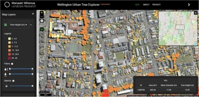
Wellington Urban Tree Explorer website.
In collaboration with Scion, University of Canterbury, Victoria University, the Institute of High Performance Computing Singapore and Nanyang Technological University, we created the Wellington Urban Tree Explorer website that has over 1.8 million trees mapped to support the city council with urban planning.
The tree height values were measured by LiDAR aerial surveys in 2019 and 2020. The data was produced by a deep learning model to identify individual tree objects and output geospatial polygons to represent tree crowns. The interactive map is easy to use and has three layers including tree crowns, height and diameter. From there, you can filter by tree height and diameter.
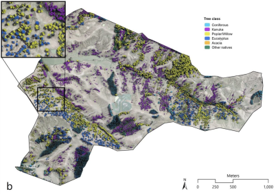
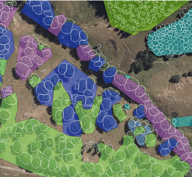
Tree species mapping in pastoral hill-country
This work was a collaboration with the Smarter Targeting of Erosion Control programme to find out what the effect of individual trees is on landslide risk. By adding individual trees and different species to a trained model, we are able to assess the landslide risk and their effect on the surrounding slope stability.
The project compared two landslide susceptibility models at a scale of individual trees on two farms in the Waiarapa that were prone to landslides. In order to run these models, you need information about the vegetation on the land. Previous methods of obtaining this data would be by using the Land Cover Database but this is on a different scale and doesn’t define individual trees, just groupings of vegetation. Our researchers mapped individual trees and classified tree species. This information was then used in the model to measure the effect of tree species on slope stability. Image g shows the landslide risk with no trees (red & yellow areas). Image h shows how adding trees and species updated landslide risk and their effect on the surrounding slope stability.
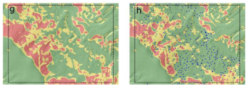
Image g and image h are outputs from one of the landslide susceptibility models.
For more information on these projects, please contact Jan Schindler.
Survey of Rural Decision Makers
Make sure your voice is heard
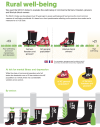
Download the SRDM 2021 results overview
The Survey of Rural Decision Makers is one of the largest and longest-running rural surveys in the world.
Led by Pike Stahlmann-Brown and run every two years, thousands of farmers, foresters, growers and lifestyle block owners across the country voice their opinion on topical issues to build a better picture of decision-making at farm level across the country.
Question topics range from land use and conservation to sources of advice and future planning.
The handout given on our stand contains a handful of findings from the 2021 survey. It is also available to download as a PDF.