Soils of Banks Peninsula – large complexity in a small space
Earlier soil mapping work in parts of the peninsula dates back to the 1930s. Along with efforts by the Soil Bureau in the 1980s, led by Bruce Trangmar, this laid the foundations of our understanding of the local soil types. Despite this, the peninsula had not been mapped for S-map until now.
After almost complete deforestation in the late 1800s, Banks Peninsula’s land use today is dominated by sheep and beef farms, with minor areas of exotic forestry and reserves for native vegetation. The intensity of the land use varies, mainly due to the variable topography, which can range from flat river terraces through to rolling hills and vertical cliffs. The peninsula reaches elevations of over 900 m (the highest point is Mt Herbert / Te Ahu Patiki at 919 m).
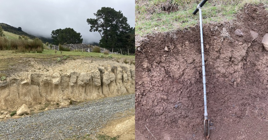
The topography drives a distinct climate gradient, from low-lying slopes that have a water deficit in summer, to higher elevations with excess moisture during most months. Adding to this variability is the presence of two distinct geological materials that provide most of the parent materials for the soils: basalt rock, as testament to the volcanic past of the peninsula, and wind-blown particles (‘loess’), originating from the much more distant greywacke sandstone of the Southern Alps (Figure 1).

Figure 1. Two soil extremes: on the left, a Pallic Soil from loess (with a distinct fragipan, a dense, drainage-impeding layer indicated by the coarse prismatic structure), which is a typical soil for the less-steep slopes at lower elevations; on the right, a Melanic Soil from basalt, a darker soil with a much finer, granular structure and varying amounts of rock fragments, more common at higher elevations and in steeper terrain.
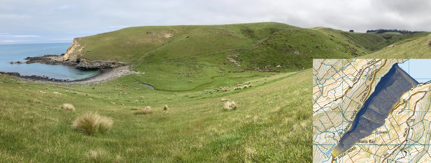
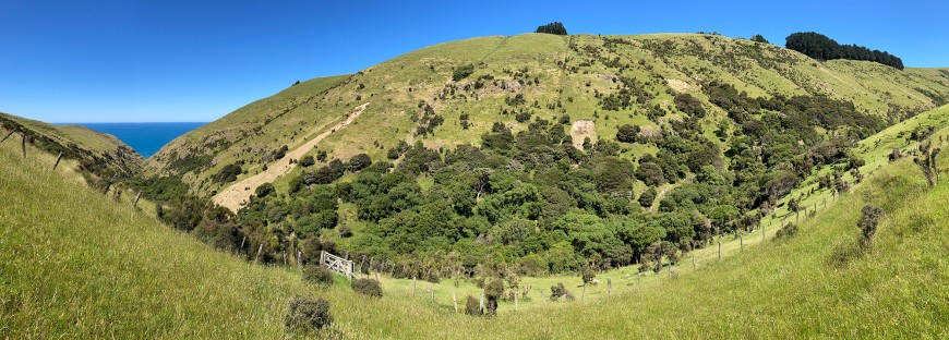
Overall, Banks Peninsula has a high spatial variability of soil types, mainly due to very active slope and fluvial processes in both the past and present. These processes include ‘fast’ landslides, slow but persistent ‘creeping’ of soil downslope, and fluvial incision and deposition – particularly during flood events. A particular challenge for soil surveying at the high level of detail required by S-map was the often-unpredictable relationship between topography and important soil properties, such as depth to bedrock and abundance of rock fragments in the soil (Figures 2 and 3).

Figure 2. One of the smaller bays, with poorly drained fluvial soils due to the ponding of the stream behind the beach wall. Some larger bays, such as Okains Bay (inset), show evidence of relict sand dunes, visible as subtle sequences of ridges running across the valley floor (yellow = high elevations, blue = low elevations), some of which are now at a considerable distance from the current beach.

Figure 3. A wide-angle view of a side slope, exemplifying the variability of soils and high geomorphic activity in Banks Peninsula. Note the alternation of rock outcrops and deeper loess cover (the yellowish-brown material as revealed by the slips) across the slope, despite similar shape and steepness of the slope.
Considering this complexity, combined with the resource constraints of soil surveys and limited access to private land, we opted for a ‘hybrid’ mapping approach. We initially sampled the survey area in a spatially balanced pattern, making observations across the many combinations of the landscape characteristics (topography, climate, geology, land cover). This site selection was computer-driven through a geostatistical algorithm, later supplemented by a more classic sampling approach using transects. These transects, chosen by the soil surveyor, crossed sequences of different landforms (e.g. a succession of levees, river terraces and fans, from foot slopes to ridge crests). This exercise helped to identify the differences in soils between landform types, and also how different landform–soil assemblages relate to each other in a landscape context.
The map units of the new soil map for Banks Peninsula were primarily based on the identified landforms, such as ridges, side slopes and valley floors, as is common in soil survey practice. However, the composition of soil types within the map units is frequently diverse, owing to the complex relationships between soils and landforms we encountered during the field work. For example, many map units that cover hillslopes consist of a mix of deep and shallow soils, or basalt-derived and loess-derived soils.
If spatial data sets with a better ability to distinguish between the two major soil parent materials (basalt and greywacke loess) were to become available for the area, we recommend a review of the survey. However, our new survey at a mapping scale of 1:50,000 is a significant improvement over the 1:253,000-scale soil map of Banks Peninsula from 1968, which it replaces, and it will support better land-use decisions across the peninsula, including sediment and nutrient management. Soil survey is a collaborative initiative, with the new map reflecting the collective contribution of Banks Peninsula farmers, ECan staff, Manaaki Whenua pedologists, laboratory and informatics staff. The new data will be publicly available through the S-map website in December.

