An updated version of the Threatened Environment Classification reflecting the status as of 2012 has recently been released, using classes of the 4th Land Cover Database (LCDB4, based on 2012 satellite imagery) and the protected areas network (2012).
The Threatened Environment Classification uses indigenous vegetation cover as a surrogate for indigenous biodiversity; the variety ofindigenous ecosystems, habitats, and communities found across New Zealand and the indigenous species, subspecies, varieties and associated genetic diversity they contain. It uses legal protection for the purpose of natural heritage protection as a surrogate for the relative vulnerability of that indigenous biodiversity to pressures such as land clearance, extractive land uses, and the effects of fragmentation. The Threatened Environment Classification is most appropriately used to provide information on the loss and protection context of indigenous vegetation that is identified on the ground. In conjunction with site survey, it can help to identify places that are priorities for formal protection against clearance and/or incompatible land uses, and for ecological restoration to restore lost species, linkages and buffers.
For more details on the creation and use of this classification, please see the updated version of the Guide for Users of the Threatened Environment Classification.
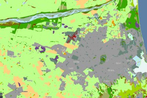
The Threatened Environment Classification is available for use freely, and can be accessed in several ways. The easiest way to explore the Threatened Environment Classification 2012 is to view it in Landcare Research’s free interactive online GIS portal classification “Our Environment”. You can also download the classification as a GIS layer or as a table. Please click on the Access formats boxes below for more information.

Landcover.
References
Walker S, Cieraad E, Barringer J 2015. The Threatened Environment Classification for New Zealand 2012: a guide for users. Landcare Research Report LC2184
Cieraad E, Walker S, Price R, Barringer J. 2015. An updated assessment of indigenous cover remaining and legal protection in New Zealand’s land environments. New Zealand Journal of Ecology 39(2).
Lloyd, K.M. and Cieraad, E. (2007). Use of LENZ and LCDB2 for determining the representative value of stands of indigenous vegetation. Presentation at the New Zealand Ecological Society Conference, Christchurch 2007.
Walker S., Price R., Rutledge D. (2008). New Zealand's remaining indigenous cover: recent changes and biodiversity protection needs. Science for Conservation 284. 82 p.
Walker, S., R. Price, D. Rutledge, R. T. T. Stephens, and W.G. Lee. (2006). Recent loss of indigenous cover in New Zealand. New Zealand Journal of Ecology 30: 169–177.