Land environments of New Zealand (LENZ)
In this section
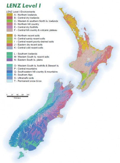
 LENZ (Land Environments of New Zealand) is an environmental classification intended to underpin a range of conservation and resource management issues. LENZ was originally envisioned as a framework for conservation management that would take advantage of the natural relationship between the environment and species distributions. Rather than occurring randomly, species tend to occur in areas having similar environmental conditions. As a consequence, similar environments tend to support similar groups of plants and animals, provided they have not been substantially modifed by human activity.
LENZ capitalises on the species-environment relationships by identifying climatic and landform factors likely to influence the distribution of species. LENZ uses these factors to define a landscape classification that groups together sites that have similar environmental conditions. Such a classification can then be used to indicate sites likely to have similar potential ecosystem character - not necessarily the same in all respects but likely to have similar groups of species and similar biological interactions and processes.
One major advantage of this approach, as opposed to directly mapping land cover for example, is its ability to predict the potential character of sites where natural ecosystems have been substantially modified (e.g. by land clearance or fire) or replaced by introduced plants and animals (e.g. pests and weeds).
Although LENZ was originally envisioned as a tool for biodiversity management, it has a much wider application. This is because the environmental factors that control the distributions of many land based plants and animals (temperature, water supply, availability of nutrients, etc.) are also factors that provide major constraints on human land uses such as agriculture, horticulture, and forestry.
Access
LENZ data layers can be accessed via the Koordinates and LRIS websites.
Tools
LENZ Distance v0.5
(34KB ArcView 3.x .avx file)
An ArcView extension that:
- calculates the environmental distance (Gower metric) used in the LENZ classification from a selected point to all other points in a view
- creates a new grid of the environmental distance values.
Copy the .avx file to your ...\arcview\ext32 directory. LENZ Distance will then be available via the Extensions dialog box that is accessed through the File menu in ArcView
Threatened Environment Classification
The Threatened Environment Classification is a source of broad (i.e. national) scale background information: specifically, how much native (indigenous) vegetation remains within land environments; its legal protection status; and how past vegetation loss and legal natural heritage protection are distributed across New Zealand’s landscape.
The Threatened Environment Classification is a combination of three national databases: Land Environments New Zealand (LENZ), classes of the 4th Land Cover Database (LCDB4, based on 2012 satellite imagery) and the protected areas network (version 2012, reflecting areas legally protected for the purpose of natural heritage protection). The classification combines this information into a simple and practical GIS tool. ‘Threatened environments’ (categories 1 to 5) are those in which much indigenous vegetation has been cleared and/or only a small proportion of what remains is legally protected.
Reports
- pdf Climate Surfaces for New Zealand. J. Leathwick, G. Wilson, & T. Stephens, 2002 pdf File, 1.7 MB
- pdf National biodiversity status: methods and summary results. Rutledge, D., Price, R., Heke, H. & Ausseil, A., 2004 pdf File, 3.3 MB
- pdf New Zealand's indigenous cover: recent changes and biodiversity protection needs. Walker, S., Price R., & Rutledge, D., 2005 pdf File, 2.6 MB
- pdf Spatial Prediction of the Potential Range of Three Threatened Plant Species in the Waikato Region. D. Rutledge, M. Merritt, & B. Burns, 2004 pdf File, 1.9 MB
Applications
Some applications which use LENZ include:
- assessing the biodiversity value of surviving natural ecosystem remnants and their ability to represent historic biotic patterns;
- identifying the most efficient use of limited financial resources for biodiversity management, including management of protected natural areas and other areas of land with high biodiversity values;
- identifying sites where similar problems are likely to arise in response to human activities, or where similar management activities are likely to have a particular affect;
- identifying the geographic extent over which results from site-specific studies can be reliably extended;
- providing a framework for regulatory activities and reporting on the state of the environment;
- setting targets for restoration projects, including identifying suitable sources of plants and animals for re-establishment;
- identifying environments throughout the world that are similar to New Zealand's environments to assist with predicting what new harmful organisms could successfully establish and spread in New Zealand if they were to arrive;
- optimising the management of productive land uses, including locating optimal sites for particular crops or cultivars.


