Cyathea dealbata - Melicytus ramiflorus - Freycinetia baueriana - Ripogonum scandens forest
In this section
Common name: Silver fern - mahoe forest
Code: A: BPF4
Where does it occur?
This 605 000 ha alliance occurs in North Island lowland and lower montane areas. Altitudes range from sea level to 760 m. Mean annual temperatures are high compared with other alliances (average 13.1 ± 0.13° C).
Description
The forest is dominated by Cyathea dealbata, Melicytus ramiflorus and the climbers Freycinetia baueriana and Ripogonum scandens. Diagnostic species include Rhopostylis sapida, Dysoxylum spectabile, Blechnum filiforme, Freycinetia baueriana, Beilschmiedia tarairi and the climbing fern Lygodium articulatum.Important subcanopy species are Pseudopanax crassifolius, Schefflera digitata, Coprosma grandifolia, Clematis paniculata, Myrsine australis, Olearia rani and the tree fern Dicksonia squarrosa.

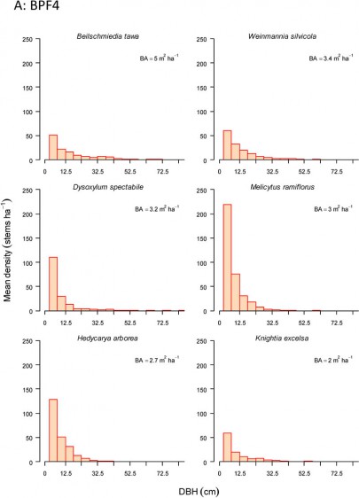
A: BPF4. Size structure of canopy dominants.
On the ground layer important species are Microsorum pustulatum, Uncinia uncinata, Astelia solandri, Blechnum filiforme, and Asplenium oblongifolium. Climbing rata are common, especially Metrosideros perforata and M. diffusa. Species richness is high with on average 56 species per plot, with half of these (28) being measurable trees. Ferns are important in this forest class, comprising on average 34% of the species (mean = 19 per plot, range 6–32), the most frequent being Microsorum pustulatum, Asplenium flaccidum and A. polyodon. Exotic species richness is low to moderate (mean = 2 per plot, range 0–25) but no individual species is particularly frequent. This class has a highest representation of species that provide resources for birds.
Indicator species
Co-occurrence of Cyathea dealbata and Ripogonum scandens OR
Dysoxylum spectabile, Geniostoma rupestre and Hedycarya arborea.
Stand characteristics
| Mean canopy height (m): | 18 m (range 6–38) |
| Mean stem density (stems/ha): | 3712 (224) |
| Mean basal area (m2/ha): | 56 (2.4) |
Synonyms
| Relationship | Name | Author |
|---|---|---|
| overlaps with | Broadleaved scrub/forest | Singers & Rogers (unpublished) |
| overlaps with | Tawa, kohekohe, mangeao, broadleaved, podocarp forest | Singers & Rogers (unpublished) |
| overlaps with | Conifer/broadleaved forests of lower altitudes: Mixed forests of Northland and Auckland | Wardle (1991) |
| overlaps with | Conifer/broadleaved forests of lower altitudes: Volcanic Plateau | Wardle (1991) |
Component Associations
Dysoxylum spectabile - Rhopalostylis sapida - Melicytus ramiflorus (Beilschmiedia tarairi) / Freycinetia banksii - Cyathea dealbata - Ripogonum scandens forest
Common name: Kohekohe – nikau – māhoe forest
Code: a: OF2
Where does it occur?
This 98 300 ha association has been sampled from largely coastal sites on the northern half of of the North Island. Sites range from flat to steeply sloping (51º). Altitudes range from 20 to 485 m.
Description
On average, this forest association is 19 m tall but can reach 38 m.It tends to be species rich with, on average, 51 species on a plot with very few (less than 1%) being exotic.
Beilschmiedia tawa - Melicytus ramiflorus - Hedycarya arborea - Knightia excelsa / Cyathea dealbata - Ripogonum scandens forest
Common name: Tawa – māhoe – pigeonwood – rewarewa forest
Code: a: BL2
Where does it occur?
This 83 200 ha association has been sampled primarily from scattered sites in the upper mid North Island but also from the Kapiti Coast, Marlborough Sounds and Southland. Sites range from flat to steeply sloping (47º). Altitude ranges from 35 to 700 m.
Description
This forest association is, on average, 17 m tall but can range from 9 to 38 m. It tends to be species-rich with an average of 39 species on a plot which can range from 22 to 62.On average, there are very few (less than 1%) exotic species present.
References
Wiser, S.K., Hurst, J.M. 2010. Composition and structure of 24 New Zealand forest and shrubland vegetation communities. Landcare Research Contract Report LC0910-073. Prepared for the Department of Conservation and the Sustainable Management Fund of the Ministry of Agriculture and Forestry.
Wiser, S.K., J.M. Hurst, R.B. Allen, E.F. Wright. 2011. New Zealand’s forest and shrubland communities: a classification based on a nationally representative plot network. Applied Vegetation Science 14: 506-523.
Wiser, S.K.; De Cáceres, M. 2013. Updating vegetation classifications: an example with New Zealand's woody vegetation. Journal of Vegetation Science 24: 80-93.
De Cáceres M, Legendre P, Wiser SK, Brotons L (2012) Using species combinations in indicator value analyses. Methods in Ecology and Evolution 3(6): 973-982.


