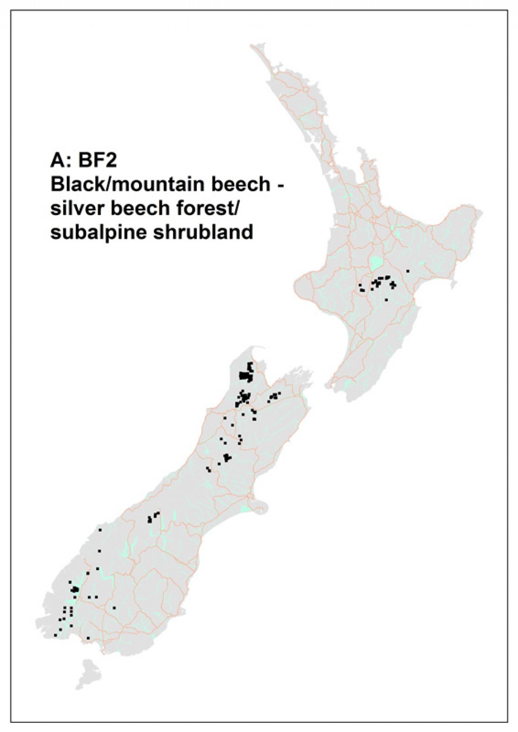
Common name: Black/mountain beech - silver beech forest/subalpine shrubland Code: A: BF2
![[Nothofagus solandri] – [Nothofagus menziesii] / [Coprosma pseudocuneata] – [Hymenophyllum multifidum] forest. Cobb Ridge, Kahurangi National Park](/assets/Publications/Woody-ecosystem-types/Nothofagus_solandri_N_menziesii_Coprosma_pseudocuneata_Hymenophyllum_multifidum_forest__ResizedImageWzQwNSwyNzBd.jpg "[Nothofagus solandri] – [Nothofagus menziesii] / [Coprosma pseudocuneata] – [Hymenophyllum multifidum] forest. Cobb Ridge, Kahurangi National Park")
[Nothofagus solandri] – [Nothofagus menziesii] / [Coprosma pseudocuneata] – [Hymenophyllum multifidum] forest. Cobb Ridge, Kahurangi National Park
Where does it occur?
This 265 000 ha alliance occurs from 130–1420 m altitude in the South Island and central North Island and, at higher altitudes, grades into subalpine shrubland. It occurs on a range of landforms, from gently sloping terraces to ridges and steep (up to 54 degrees) faces.
Description
The canopy is dominated by Nothofagus solandri and N. menziesii. Other important canopy species (but seldom reaching >5 m tall) include Phyllocladus alpinus and Griselinia littoralis. In the subcanopy these are frequently joined by Myrsine divaricata, Coprosma pseudocuneata and C. tayloriae.

Size structure of canopy dominants.
Important species in the ground layer are Hymenophyllum multifidum, which typically has high cover as well as very high frequency, and Polystichum vestitum, Grammitis billardierei, Blechnum penna-marina and Lagenifera strangulata. Species most frequently occurring epiphytically are Grammitis magellanica, Hymenophyllum multifidum, H. villosum, H. sanguinolentum, Grammitis billardierei, and Asplenium flaccidum. Species richness is moderate with on average 30 species per plot, with 11 of these being measurable trees. There are few exotic species in this class; the most frequent is Mycelis muralis.
Indicator species
Co-occurrence of Coprosma pseudocuneata and Nothofagus solandri.
Stand characteristics
| Mean canopy height (m): | 15 m (range 3–35) |
| Mean stem density (stems/ha): | 3203 (266) |
| Mean basal area (m2/ha): | 62 (3.4) |
Synonyms
| Relationship | Name | Author |
|---|---|---|
| overlaps with | Beech forests: northern South Island | Wardle (1991) |
| overlaps with | Beech forests: Central and southern South Island | Wardle (1991) |
| overlaps with | Beech forests: North Island axial ranges | Wardle (1991) |
| overlaps with | Beech forests: other beech stands of the North Island | Wardle (1991) |
Nothofagus solandri / Griselinia littoralis – Phyllocladus alpinus – Raukaua simplex – Coprosma tayloriae / Grammitis billardierei forest
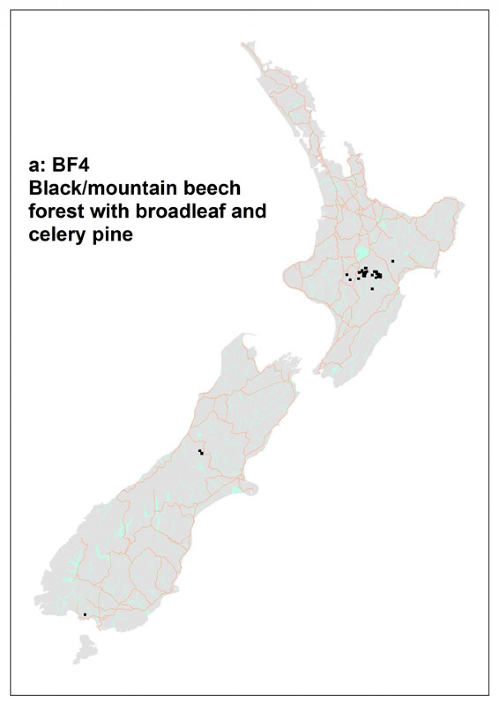
Common name: Black/mountain beech forest with broadleaf and celery pine
Code: a: BF4
Where does it occur?
This 68 000 ha association has been sampled primarily on the Kaimanawa Mountains and Kaweka Range of the North Island. It was also sampled from the Arthur's Pass region of the South Island. Sites range from slight to steeply sloping (5º to 50º). Altitudes range from 130 to 1380 m.
Description
This forest association is, on average, 13 m tall but can range from 3 to 20 m. It tends to contain a moderate amount of species with an average of 30 species on a plot which can range from 10 to 54. On average, there are very few (less than 1%) exotic species present.
Nothofagus solandri – N. menziesii forest
![The [Nothofagus solandri] – [Nothofagus menziesii] forest association is typically species poor with a sparse understorey. Cobb Ridge, Kahurangi National Park.](/assets/Publications/Woody-ecosystem-types/Nothofagus_solandri_N_menziesii_forest_association__ResizedImageWzQwNSwyNzBd.jpg "The [Nothofagus solandri] – [Nothofagus menziesii] forest association is typically species poor with a sparse understorey. Cobb Ridge, Kahurangi National Park.")
The [Nothofagus solandri] – [Nothofagus menziesii] forest association is typically species poor with a sparse understorey. Cobb Ridge, Kahurangi National Park.
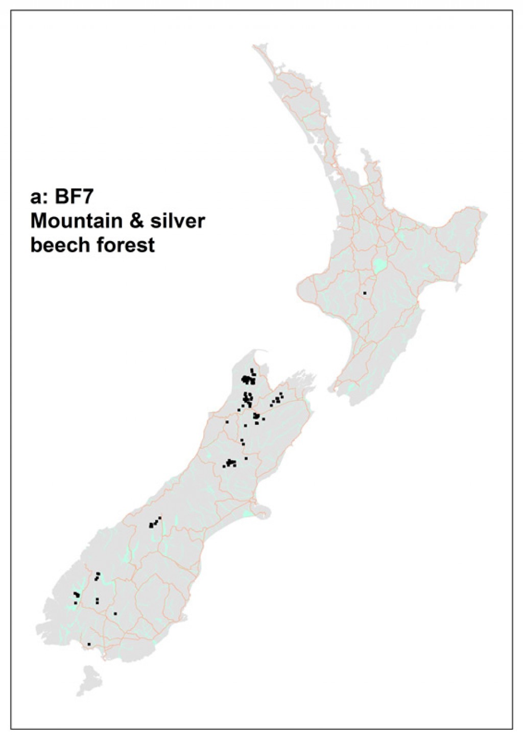
Common name: Mountain & silver beech forest
Code: a: BF7
Where does it occur?
This 90 800 ha association has been sampled primarily on the South Island in montane areas north of Arthur's Pass, in western Southland and Fiordland. One plot in this association was sampled from forests in the volcanic area south of Lake Taupo. Sites range from flat to very steeply sloping (65º). Altitudes range from 100 to 1420 m.
Description
Only two species, besides Nothofagus solandri and N. menziesii, occur with a frequency higher than 45% -- Coprosma pseudocuneata and Grammitis billardierei. Understories can be very sparse.On average stands are 16 m tall, but may be up to 30 m tall.These forests are relatively species-poor, with on average 15 species, but can reach 37, recorded on a plot. Of these fewer than 1%, on average, are exotic.
Nothofagus solandri – N. menziesii / Griselinia littoralis – Myrsine divaricata – Coprosma pseudocuneata forest and subalpine shrubland
![[Nothofagus solandri] – [Nothofagus menziesii] / [Griselinia littoralis] – [Myrsine divaricata] – [Coprosma pseudocuneata] forest. Cobb Valley, Kahurangi National Park.](/assets/Publications/Woody-ecosystem-types/Nothofagus_solandri_-N_menziesii_Griselinia_littoralis_Myrsine_divaricata_Coprosma_pseudocuneata_forest__ResizedImageWzQwNSwyNzBd.jpg "[Nothofagus solandri] – [Nothofagus menziesii] / [Griselinia littoralis] – [Myrsine divaricata] – [Coprosma pseudocuneata] forest. Cobb Valley, Kahurangi National Park.")
[Nothofagus solandri] – [Nothofagus menziesii] / [Griselinia littoralis] – [Myrsine divaricata] – [Coprosma pseudocuneata] forest. Cobb Valley, Kahurangi National Park.
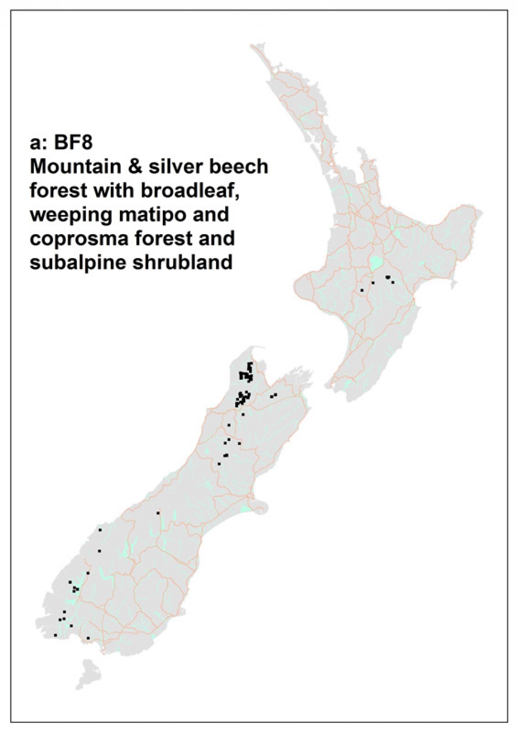
Common name: Mountain & silver beech forest with broadleaf, weeping matipo and coprosma forest and subalpine shrubland
Code: a: BF8
Where does it occur?
This 106 000 ha association has been sampled has been sampled on the South Island in montane areas west of the Main Divide, outside of the "beech gap", in the Richmond Range, and on the North Island in the Kaimanawa and Kaweka ranges. Sites range from flat to very steeply sloping. Altitudes range from 170 to 1390 m.
Description
In addition to the nominal species, the small tree Phyllocladus alpinus, the shrub Coprosma foetidissima and the fern Grammitis billardierei are common in stands of this association. On average stands are 15 m tall, but may be up to 27 m tall.These forests have moderate numbers of species, with on average 25 species, but can reach 64, recorded on a plot. Of these fewer than 1%, on average, are exotic.
Nothofagus fusca – (N. solandri) / Carpodetus serratus – Griselinia littoralis forest
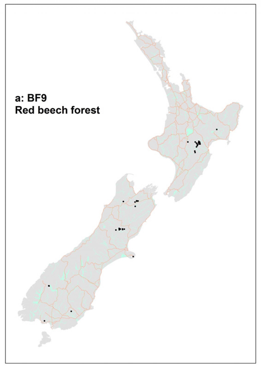
Common name: Red beech forest
Code: a: BF9
Where does it occur?
This 37 800 ha association has been sampled largely from the Kaweka Range in the North Island and in several scattered locations the length of the South Island. Sites range from flat to steeply sloping (42º). Altitudes range widely from 60 to 1120 m.
Description
This forest association is, on average, 21 m tall but can range widely from 8 to 40 m. It tends to contain a moderate amount of species with an average of 21 species on a plot but can also reach 43. On average, there are few (less than 2%) exotic species present
Nothofagus fusca – N. menziesii – N. solandri (Podocarpus hallii) /Leucopogon fasciculatus – Pseudopanax crassifolius forest
![A stand of the [Nothofagus fusca] – [Nothofagus menziesii] – [Nothofagus solandri] ([Podocarpus hallii]) / [Leucopogon fasciculatus] – [Pseudopanax crassifolius] forest association. Bullock Track, Kahurangi National Park.](/assets/Publications/Woody-ecosystem-types/Nothofagus_fusca_N_menziesii_N_solandri_Leucopogon_fasciculatus_Pseudopanax_crassifolius_forest_association__ResizedImageWzQwNSwyNzBd.jpg "A stand of the [Nothofagus fusca] – [Nothofagus menziesii] – [Nothofagus solandri] ([Podocarpus hallii]) / [Leucopogon fasciculatus] – [Pseudopanax crassifolius] forest association. Bullock Track, Kahurangi National Park.")
A stand of the [Nothofagus fusca] – [Nothofagus menziesii] – [Nothofagus solandri] ([Podocarpus hallii]) / [Leucopogon fasciculatus] – [Pseudopanax crassifolius] forest association. Bullock Track, Kahurangi National Park.
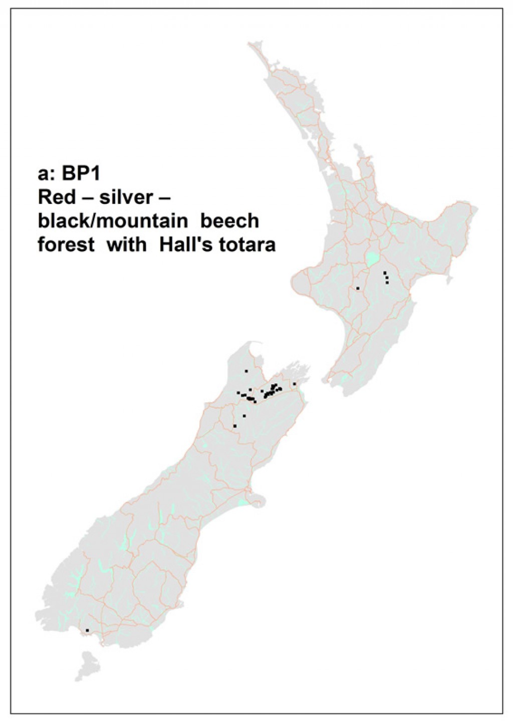
Common name: Red – silver – black/mountain beech forest with Hall's totara
Code: a: BP1
Where does it occur?
This 60 500 ha association has been sampled on the South Island primarily in montane areas north of Lewis Pass.It has also been recorded in Southland and on the North Island from the Kaweka Range. Sites range from those that are flat to those having steep (45º) slopes. Altitudes range from 260 – 1260 m.
Description
In addition to the nominal species, the subcanopy tree Eleaocarpus hookerianus, the shrubs Coprosma microcarpa, C. rhamnoides and Leptocophylla juniperina, and the fern Grammitis billardierei can be important in this association.On average stands are 23 m tall, but may be up to 33 m tall.These forests have moderate numbers of species with on average 24 species, but as few as 13 and as many as 45, recorded on a plot. Only 1% of these, on average, are exotic.
Indicator species
Nothofagus fusca and Nothofagus menziesii always co-occur in this association.Co-occurence of these two species with the combinations of either Leptecophylla juniperina, Coprosma microcarpa and Nothofagus solandri OR
Leptecophylla juniperina, Coprosma microcarpa and Elaeocarpus hookerianus.
Known distribution maps
References
Wiser, S.K., Hurst, J.M. 2010. Composition and structure of 24 New Zealand forest and shrubland vegetation communities. Landcare Research Contract Report LC0910-073. Prepared for the Department of Conservation and the Sustainable Management Fund of the Ministry of Agriculture and Forestry.
Wiser, S.K., J.M. Hurst, R.B. Allen, E.F. Wright. 2011. New Zealand’s forest and shrubland communities: a classification based on a nationally representative plot network. Applied Vegetation Science 14: 506-523.
Wiser, S.K.; De Cáceres, M. 2013. Updating vegetation classifications: an example with New Zealand's woody vegetation. Journal of Vegetation Science 24: 80-93.
De Cáceres M, Legendre P, Wiser SK, Brotons L (2012) Using species combinations in indicator value analyses. Methods in Ecology and Evolution 3(6): 973-982.