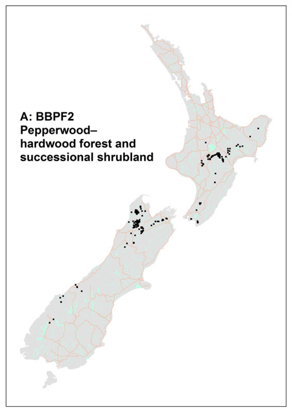
Common name: Pepperwood–hardwood forest and successional shrubland
Code: A: BBPF2
Where does it occur?
This alliance occupies 454 000 ha between 38° and 43°S on the North and South islands. It occurs in montane areas from 300–1200 m altitude.
Description
The alliance is dominated by Pseudowintera colorata, Griselinia littoralis, Nothofagus fusca, N. menziesii and Carpodetus serratus, with Weinmannia racemosa dominant in some stands. Other important species are Rubus cissoides in the canopy and Coprosma foetidissima, C. tayloriae and Neomyrtus pedunculata in the subcanopy.

A: BBPF2. Size structure of canopy dominants.
The understorey is dominated by Microlaena avenacea. Other important species in the ground layer include Blechnum fluviatile, B. procerum, B. discolor and Histiopteris incisa. Species most frequently occurring epiphytically are Asplenium flaccidum, Grammitis billardierei, broadleaf and Hymenophyllum sanguinolentum. Species richness is moderate with on average 42 species per plot, with 20% of these (18) being measurable trees. A relatively large proportion of the species present are ferns, these comprising on average 32% of the total species richness (mean = 13 species per plot, range 7–23), the most frequent being Asplenuium flaccidum, Grammitis billardierei and Blechnum fluviatile. Exotic species richness is low (mean = 1, range 0–5), and no individual species was particularly frequent. This class has a high proportion of goat-avoided species.
Indicator species
Co-occurrence of Astelia nervosa, Coprosma colensoi, Nothofagus solandri and Weinmannia racemosa OR
Nothofagus fusca and Pseudowintera colorata.
Stand characteristics
| Mean canopy height (m): | 23 m (range 5–35) |
| Mean stem density (stems/ha): | 3910 (443) |
| Mean basal area (m2/ha): | 69 (5.0) |
Synonyms
| Relationship | Name | Author |
|---|---|---|
| is included within | Red, silver beech forest | Singers & Rogers (unpublished) |
| overlaps with | Beech forests: northern South Island | Wardle (1991) |
| overlaps with | Beech forests: Central and southern South Island | Wardle (1991) |
| overlaps with | Beech forests: North Island axial ranges | Wardle (1991) |
| overlaps with | Beech forests: other beech stands of the North Island | Wardle (1991) |
Component associations
Nothofagus fusca – N. menziesii / Pseudowintera colorata – Griselinia littoralis – Carpodetus serratus / Blechnum fluviatile forest
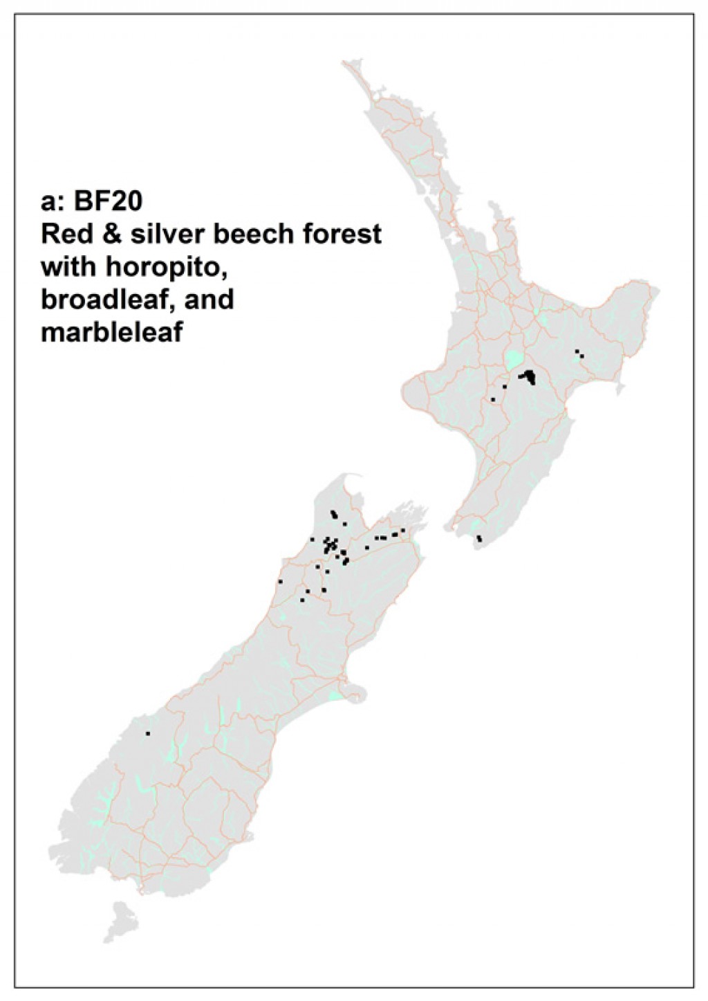
Common name: Red & silver beech forest with horopito, broadleaf, and marbleleaf
Code: a: BF20
Where does it occur?
This90 700 ha association has been sampled from the north west of the South Island and in the southern Wairarapa and central North Island. Sites range from flat to steeply sloping (42º). Altitudes range from 80 to 750 m.
Description
This forest association is, on average, 25 m tall but can range widely from 5 to 35 m. It tends to contain a moderate amount of species with an average of 34 species on a plot which can range from 11 to 57. On average, there are very few (less than 1%) exotic species present.
Weinmannia racemosa – Pseudowintera colorata – Carpodetus serratus – Griselinia littoralis / Asplenium flaccidium – Blechnum discolor forest
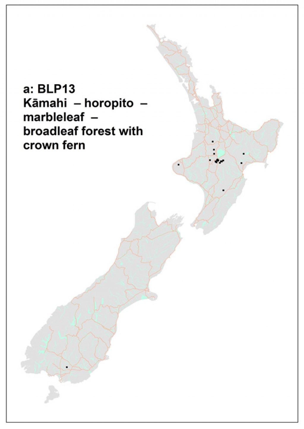
Common name: Kāmahi – horopito – marbleleaf – broadleaf forest with crown fern
Code: a: BLP13
Where does it occur?
This 30 250 ha association was sampled primarily from around the Lake Taupo region but also in scattered locations of the central North Island. Sites range from near flat to steeply sloped (51º). Altitudes range from 320 to 1050 m.
Description
This forest association is, on average, 15 m tall but can range from 4 to 30 m. It tends to be species-rich with an average of 45 species on a plot which can range from 25 to 68. On average, there are few (less than 2%) exotic species present.
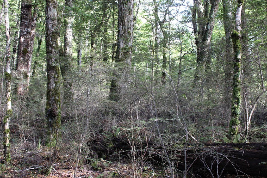
Nothofagus fusca – N. menziesii / Griselinia littoralis – Myrsine divaricata – Coprosma foetidissima / Grammitis billardierei forest
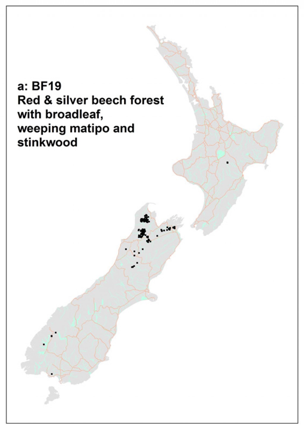
Common name: Red & silver beech forest with broadleaf, weeping matipo and stinkwood
Code: a: BF19
Where does it occur?
The main centres of this 98 300 ha association are in the Tasman Mountains and Matiri Range areas of NW Nelson with scattered locations from Harper Pass to Picton. Sites range from flat to steeply sloping (50º) with altitudes ranging from 130 to 1200 m.
Description
Besides the nominal species, the subcanopy trees Raukaua simplex and Pseudowintera colorata, and the shrubs Coprosma rhamnoides and C. colensoi commonly occur in stands of this association. On average stands are 22 m tall, but may be up to 40 m tall.These forests have, on average, 27 species, but as few as 12 and as many as 52, recorded on a plot. On average, fewer than 1% of species present are exotic.
Indicator species
Nothofagus fusca and Nothofagus menziesii always co-occur in this association.Co-occurence of these two species with the combinations of either Raukaua simplex,Polystichum vestitum and Cyathea colensoi ORGriselina littoralis, Coprosma pseudocuneata and Cyathea colensoi OR
Coprosma foetidissima, Coprosma colensoi, Polystichum vestitum and Coprosma ciliata OR
Coprosma colensoi, Pseudowintera colensoi, Coprosma ciliata and Nertera dichondrifolia sensu lato.
![[Nothofagus fusca] – [Nothofagus menziesii] / [Griselinia littoralis] – [Myrsine divaricata] – [Coprosma foetidissima] / [Grammitis billardierei] forest, Cobb Valley, Kahurangi National Park. Image](/assets/Publications/Woody-ecosystem-types/N_fusca_N_menziesii_Griselinia_littoralis_Myrsine_divaricata_Coprosma_foetidissima_Grammitis_billardierei__ScaleWidthWzEwMjRd.jpg)
![[Griselinia littoralis] and [Myrsine divaricata] are frequent in stands of this association. Cobb Valley, Kahurangi National Park. Image](/assets/Publications/Woody-ecosystem-types/Griselinia-littoralis-Myrsine_divaricata__ScaleWidthWzEwMjRd.jpg)
![[Grammitis billardierei] typically occurs in the understorey of this association. Image](/assets/Publications/Woody-ecosystem-types/Grammitis-billardierei__ScaleWidthWzEwMjRd.jpg)
![[Nothofagus fusca] – [Nothofagus menziesii] / [Griselinia littoralis] – [Myrsine divaricata] – [Coprosma foetidissima] / [Grammitis billardierei] forest, Cobb Valley, Kahurangi National Park. Image](/assets/Publications/Woody-ecosystem-types/forest_floor__ScaleWidthWzEwMjRd.jpg)
Nothofagus menziesii / Pseudowintera colorata – Griselinia littoralis / Asplenium flaccidum – Polystichum vestitum – Grammitis billardierei forest
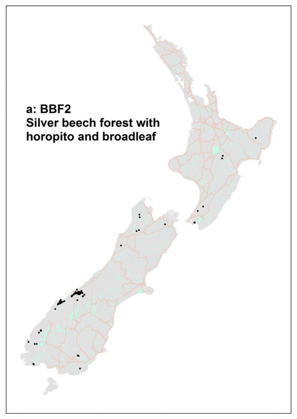
Common name: Silver beech forest with horopito and broadleaf
Code: a: BBF2
Where does it occur?
This 60 500 ha association was sampled from scattered locations from East Cape to western Southland with most sampled from South Westland. Sites range from flat to very steeply sloping (70º) with altitudes ranging from near sea level to 1100 m.
Description
This forest association is, on average, 21 m tall but can reach 30 m. It tends to contain a moderate amount of species with an average of 33 species on a plot which can range from 17 to 60. On average, there are very few (less than 1%) exotic species present.
Known distribution maps
References
Wiser, S.K., Hurst, J.M. 2010. Composition and structure of 24 New Zealand forest and shrubland vegetation communities. Landcare Research Contract Report LC0910-073. Prepared for the Department of Conservation and the Sustainable Management Fund of the Ministry of Agriculture and Forestry.
Wiser, S.K., J.M. Hurst, R.B. Allen, E.F. Wright. 2011. New Zealand’s forest and shrubland communities: a classification based on a nationally representative plot network. Applied Vegetation Science 14: 506-523.
Wiser, S.K.; De Cáceres, M. 2013. Updating vegetation classifications: an example with New Zealand's woody vegetation. Journal of Vegetation Science 24: 80-93.
De Cáceres M, Legendre P, Wiser SK, Brotons L (2012) Using species combinations in indicator value analyses. Methods in Ecology and Evolution 3(6): 973-982.