The programme is led by Manaaki Whenua – Landcare Research in collaboration with NIWA, Massey University, Waikato University, international researchers, programme partners Whanganui iwi (Tamaūpoko Community group) and Rangitāne o Manawatū, as well as several regional councils.
 Our research will improve understanding of where erosion occurs, how much and what type of sediment is produced and by which processes, and how erosion and sediment transport can be targeted and mitigated cost-effectively to reduce storm damage and improve water quality. We will measure and predict sediment quality (particle size and composition), which controls impacts on water quality and develop modelling frameworks for use by regional councils, land managers, and iwi to help the implementation of government and regional policy to maintain land productivity and reduce sediment and other contaminant loads (e.g. phosphorus) in rivers.
Research is focusing on four catchments across New Zealand: the Manawatu – for new and continuing data collection; the Whanganui – to investigate impacts from the 2018 storm and legacy sediments; and the Oreti in Southland and Wairoa near Auckland – to research storm event sediment loads and sediment source fingerprinting methods in collaboration with NIWA’s Managing Mud programme.
Recent results from STEC include developing and applying quantitative approaches for determining shallow landslide susceptibility, geochemical sediment fingerprinting to identify catchment sources of fine sediment, and a new model to predict spatial patterns in riverbank erosion.
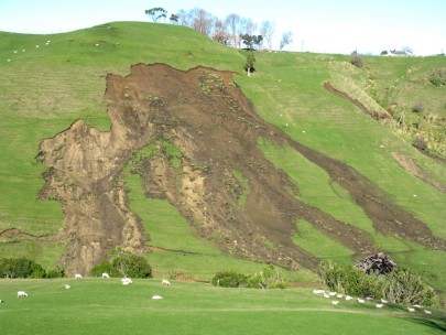
Existing assessments of storm-generated landslide susceptibility in NZ are generally qualitative and based at resolutions too low for finer scale targeting of erosion control. Higher resolution, and quantitative and consistent estimates of shallow landslide susceptibility are needed. We are employing machine learning algorithms using data from mapping of landslide scars and information on landscape factors influencing landslide occurrence to predict spatial patterns in susceptibility. We have applied this approach with initial data for the Horizons Region (Fig. 1) and are now expanding our analysis with further mapping of landslides within the Waikato and Hawke’s Bay Regions.

Figure 1. Shallow landslide susceptibility predicted with a random forest model using available data to determine the relative likelihood of landslide occurrence based on terrain, soil and land cover attributes for the Horizons region.
Our research using sediment source fingerprinting techniques includes new data collection in the Oreti, Tiraumea (Manawatu), and Aroaro (Wairoa, Auckland) catchments. Initial results from the Oreti catchment show for the first time how we can spatially discriminate bank erosion source contributions using downstream variations in floodplain geochemistry. In the Aroaro catchment we are collaborating with NIWA to compare source predictions based on geochemical and compound specific stable isotope (CSSIs) sediment tracers. Initial results show that geochemical fingerprinting successfully discriminated erosion process sources (i.e. surface, shallow landslide, and stream bank erosion). Future work will compare results based on geochemical and CSSI sediment tracers.
Our new model for predicting spatial patterns in riverbank erosion improves on previous estimates of bank erosion within the SedNetNZ model. The new model better represents spatial variability in factors influencing bank erosion such as riparian woody vegetation, soil texture, and valley confinement. We tested the new model in the Manawatu catchment using reach-scale mapping of channel planform change and results were recently published in the New Zealand Journal of Marine and Freshwater Research.
Further reading
Smith HG, Spiekermann R, Dymond J, Basher L (2019) Predicting spatial patterns in riverbank erosion for catchment sediment budgets. New Zealand Journal of Marine and Freshwater Research 53: 338–362. https://www.tandfonline.com/doi/full/10.1080/00288330.2018.1561475