Adding geomorphic context to S-map via soil landform trees
S-map is New Zealand’s soil survey database, an ongoing project to map New Zealand's soil resources online at a nominal 1:50 000 scale. As of August 2021, S-map coverage stood at 37% of New Zealand. S-map is built on a hierarchical classification of soils, enabling comparison of soils across New Zealand. Soil ‘siblings’, members of a family of soils, are mapped to 1 m depth using a mix of traditional sampling and mathematical modelling methods.
In New Zealand and elsewhere, traditional soil surveys had two legends – one according to soil type (soil taxonomy) and one that listed soils according to the dominant landforms in the survey area (physiographic legend). The second legend, along with an associated narrative in each survey report, captured the relationship between the soils and the landscape. Until recently, however, S-map had no means to capture this geomorphic context of new mapping, nor to access the wealth of knowledge about soil landform relationships recorded in old survey reports.

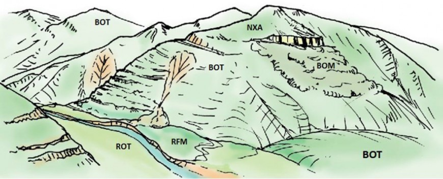
Landform diagram. BOT = Typic Orthic Brown, RFM = Mottled Fluvial Recent, ROT = Typic Orthic Recent, NXA = Acidic Oxidic Granular.
In response, a new S-map module has been developed in which soil scientists can build ‘landform trees’ that add in the geomorphic context of a soil. The module adopts the hierarchy proposed by Lynn and Basher (Table 1), adding another level below the land system level called a “land unit”. A land unit is defined as the geographical entity occupied by uniform soil-forming drivers, except for variation in one aspect – climate, associated geology, topography or chronological sequence. An optional sub-region level is also added.
Table 1: Land form hierarchy used in S-map
| Term | Definition | Examples | Scale |
|---|---|---|---|
| Land province | A major geomorphic zone, an assemblage of surface forms expressive of large-scale lithological association(s), tectonic regime, and climate. | Axial mountains and associated intermontane basins. | 1:250,000 to 1:2,000,000 |
| Land region | Lithological based macro-relief units (landscape) at scales smaller than 1:250,000, frequently bounded by structural dislocations (e.g. major faults) or contrasting rock terranes. They may cover a range of climates or be separated by climate regime. An assemblage of land systems. | Mountain range, lowland plains. | 1:100,000 to 1:250,000 |
| Land sub-region | Optional level. Distinctive landscapes determined primarily by contrasts in lithology and their response to erosion processes, sediment generation, storage, and flow. | Landscapes developed on hard rocks (controlled drainage) vs soft rocks (dendritic drainage). | 1:50,000 to 1:125,000 |
| Land system | Recurring pattern of topography, rock types, with or without significant cover beds, and soils with a relatively uniform climate/soil moisture regime. An assemblage of land units. | Large floodplain and river terrace systems. | 1:25,000 to 1:100,000 |
| Land unit | The geographic entity where all but one of the soil-forming factors remains constant across space, e.g. gross topo, litho, climo or chrono sequence, i.e. where there is one primary driver of soil variation. It is acceptable to have a dual sequence if this is pragmatic. | Lithosequence where material texture and depth change with distance from source. | 1:25,000 to 1:100,000 |
| Land component | Genetically uniform with similar age and surface materials. These are the individual parts of the land unit sequence. | Hill-country drainage basin erosion sequence, terrace age. | 1:10,000 to 1:25,000 |
| Landform element | Genetically uniform with similar climate, lithology, topographical position and age. | Ridge, shoulder, valley, north, south. | 1:100 to 1:25,000 |
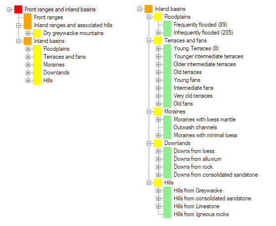
Each part of a landform tree (Fig. 1) has a descriptive name and can be further explained by means of narrative, sketches, annotated photos, soil-landscape diagrams, and even audio-video files for oral descriptions. This information will appeal to a range of learning styles.

Figure 1 Landform tree for part of the South Island. The left tree shows the Land Provine to Sub-region level, the right tree shows Land Region to Land System level.
A landform tree can be traced in two directions. Upwards allows the geomorphic context of a given location in New Zealand to be understood at increasingly broad scales. Downwards allows much of the detailed soil-landform material usually only found in a traditional paper publication to be accessed. The descriptive information can be provided in a variety of ways, enabling a range of users to access knowledge of soil formation. This type of knowledge is particularly important to Māori as it better matches a te ao Māori world view than traditional soil taxonomy.
A key application will be enabling land managers to understand and map their land at more detailed scales. Because the new module will provide information on the relationships between soils and landforms, land managers will be able to link their observations and knowledge to the science underpinning the S-map information system. An associated tool (Sibling Finder) is designed to facilitate the identification of soil siblings by land managers by searching the S-map database using their own observations of soil characteristics.
Landform trees have been created for some regions and the landform name and short description are now available on the new S-map Māori factsheet on S-map Online. The intent is that this information will be captured as part of new surveys going into S-map. Funding will need to be secured to complete the landform trees for other areas with existing S-map data coverage.
Reference
Lynn IH, Basher LR 1994. Application of soil-landscape modelling to characterise soil patterns within land systems. In: Webb TH ed. Soil-landscape modelling in New Zealand. Proceedings of a workshop held at Aokautere, New Zealand, 8–9 February 1993. Lincoln: Manaaki Whenua Press. Pp. 38–51.
Key contact

