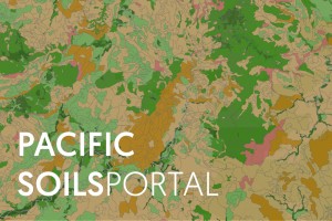
Soil map of Fiji showing land use capability classes
As new online tools have been developed, researchers have also been championing the concept of an online Pacific soils tool. The Pacific Soils Portal, launched in 2020, has been developed by Manaaki Whenua in collaboration with CSIRO Agriculture and Food, the Secretariat of the Pacific Communities Land Resources Division, and PICT Agriculture Departments. It brings together soil data, dating back to the 1960s, for five Pacific countries – Fiji, Samoa, Tonga, Kiribati, and Tuvalu.
The portal currently covers, and will also link to, the New Zealand and Australian portals to showcase and compare soils across the entire South Pacific. It will also align with activities under the Food and Agriculture Organization’s Global Soil Partnership.
The portal is funded by the Australian Centre for International Agricultural Research (ACIAR), and can be viewed on computers, tablets, and smartphones.