The result of this work is the Pacific Soils Portal.
While legacy soils mapping and soils data is still relevant, it is generally hard to access and is under-utilised. Pacific land managers are keen to understand more about soils, soil fertility, and soil management practices and how these might relate to traditional knowledge and practices, and fertility and yields declining. Bringing these two knowledge platforms together can help to evolve best farm management practices that are sustainable and climate change smart.
Work on the portal has had significant support from around the region, including a 5-year funding commitment led by the Australian Centre for International Agricultural Research (ACIAR), with collaborators from MWLR, SPC-LRD and five PICTs (Fiji, Samoa, Tonga, Kiribati and Tuvalu) to support soil management for resilient agriculture in Pacific Islands.
A Pacific Soil Partnership has also united New Zealand, Australia, and 15 Pacific Island Countries and Territories (PICTs) as a regional node of the FAO Global Soil Partnership.
What is the Pacific Soils Portal?

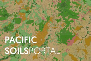
Soil map of Fiji showing land use capability classes
The Pacific Soils portal provides information and knowledge on Pacific soils, their health and uses for Fiji, Kiribati, Samoa, Tonga and Tuvalu.
The site contains
- Maps – find reports of where different soils
- Soil descriptions – information about the role different soil types play
- Crop suitability – matching crops to soils
- Sustainable soil nutrient management
- Background information on soil formation
- Resources (soil reports, maps, publications and useful contacts)
There are instructional videos to guide users.
The maps are published online as standards compliant web services (e.g. ISO 19128:2005) via a responsive browser-based web site that can be accessed from computer, tablet or smartphone. Currently, over 400 soil profile descriptions and associated soil properties are also published. The interpretive knowledge for both mapped soil polygons and detailed soil profile reports are created on-the-fly using a custom report generation tool.
A governance group has been established, led by representatives of the five countries and supported by Manaaki Whenua – Landcare Research, CSIRO in Australia, and The Pacific Community (https://www.spc.int). The governance group is evaluating hosting and funding options to ensure long-term sustainability.