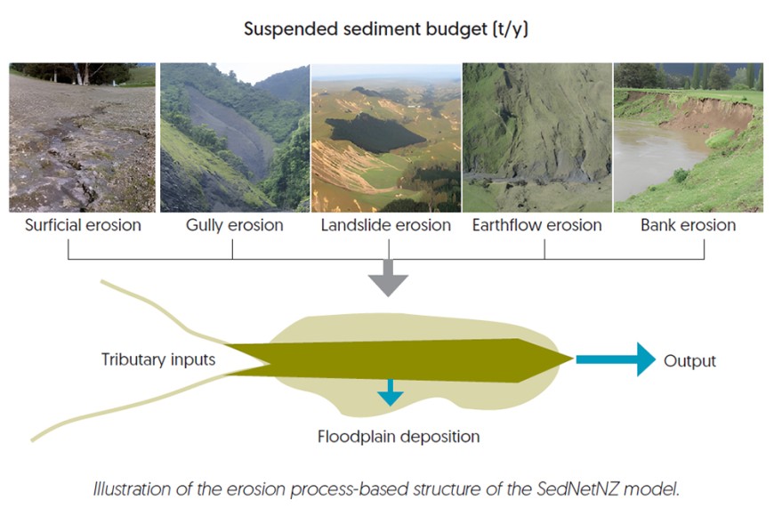
SedNetNZ is an erosion model developed by Manaaki Whenua that predicts the generation and transport of sediment through river networks, based on representation of hillslope and channel processes at the sub-catchment scale. It was first applied in the Manawatū catchment in 2013 as part of the Clean Water Productive Land research programme.
Researcher Dr Hugh Smith says that since then SedNetNZ has undergone several updates, including improvements to better represent processes such as bank erosion and development of model functions to estimate the potential effects of climate change on erosion rates and sediment loads.

SedNetNZ improves on available erosion models in AoNZ by providing estimates of sediment load generated by different erosion processes (landslides, gullies, earthflows, surface, and bank erosion) and sediment deposition on floodplains.
Researcher Dr Andrew Neverman says this allows improved targeting of erosion mitigations to the key sediment-contributing processes when modelling land management scenarios, and analysis of the linkages between upstream sediment generation and downstream sediment loading. “SedNetNZ is highly suited for scenario analysis of changes in land management and the implementation of erosion mitigation practices,” he says.
Recently, Horizons Regional Council asked Manaaki Whenua to apply the latest version of SedNetNZ in the Manawatū-Whanganui region and to update the assessment of the impact of soil conservation work to date. The council also wanted to model sediment loads under future climate change conditions for two different policy scenarios, which involved assessing both the impact of the current Sustainable Land Use Initiative (SLUI) farm plans and works on sediment loads and water clarity, and the impact once full implementation of the Freshwater Farm plans is complete.
With climate change predicted to nearly double sediment yields, the council is interested in understanding the potential impact of climate change on sediment loads. Researcher Dr Simon Vale says the model shows continued investment in SLUI and lowland erosion mitigation will be required to reduce potentially significant impacts of climate change on suspended sediment loads by late century.
“Model scenarios representing the implementation of future erosion mitigation policy show significant reductions in region-wide suspended sediment loads by late century, with the first policy scenario achieving a 48% reduction and the second achieving a 60% reduction on average, without the effects of climate change,” he says.
As well as the Horizons Regional Council work, the Manaaki Whenua researchers have recently completed SedNetNZ-based analysis of erosion and suspended sediment loads for Southland, Taranaki, Bay of Plenty, and Hawke’s Bay, while SedNetNZ modelling is currently underway for the Waikato region.
The researchers also helped Otago Regional Council to model suspended sediment loads and the reductions in load required to meet freshwater limits, which contributed to setting freshwater objectives in Otago’s Land & Water Regional Plan.
Key contacts

Andrew Neverman

