This significant achievement had its genesis two decades ago, when Manaaki Whenua partnered with Environment Canterbury (ECan) to upgrade Canterbury’s soil information. In 2020, the Ministry for Primary Industries joined the partnership, as part of its S-map expansion programme working with regional councils across Aotearoa New Zealand.
After almost complete deforestation in the late 1800s, Banks Peninsula today is dominated by sheep and beef farms, with some exotic forestry and reserves for native vegetation. Soil parent material is either basalt or wind-blown loess.

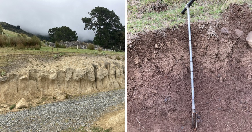
Two soil extremes: on the left, a Pallic Soil from loess (with a distinct fragipan, a dense, drainage-impeding layer indicated by a coarse prismatic structure), which is a typical soil for the less-steep slopes at lower elevations; on the right, a Melanic Soil from basalt, a darker soil with a much finer, granular structure and varying amounts of rock fragments, more common at higher elevations and in steeper terrain.
Land-use intensity varies because of the variable topography, from flat river terraces to rolling hills and vertical cliffs.
Considering this complexity, combined with the resource constraints of soil surveys and limited access to private land, pedologist Dr Andre Eger says researchers chose to use a hybrid mapping approach. “We first selected sites using a geostatistical algorithm that accounted for topography, climate, geology, and land cover. Then we added a more classic sampling approach using transects across sequences of different landforms (e.g. a succession of levees, river terraces and fans, from foot slopes to ridge crests).”
Soil survey is a collaborative initiative, and the new map reflects the collective contribution of Banks Peninsula farmers, ECan staff, Manaaki Whenua pedologists, and laboratory and informatics staff. At a scale of 1:50,000, it is a significant improvement over the 1:253,000-scale soil map of Banks Peninsula from 1968, which it replaces, and it will support better land-use decisions across the peninsula, including sediment and nutrient management.

