Raising the treasure of soil legacy data
This article highlights the work we currently do as custodians of this vast knowledge base, and why we think that ‘old’ or ‘legacy’ soil data can help us to better answer the questions of today.
It is generally acknowledged that the success of New Zealand’s ‘bio-based economy’ is highly dependent on the condition of its soil resource. An impressive amount of soil information has been generated by Manaaki Whenua and its predecessors since the 1930s. Our central repository for soils information is the National Soils Database (NSD), which contains data for some 1,500 soil profiles across the country. Because of a lack of funding for maintaining and developing land resource databases and information, soils data gathered since the mid-1990s were no longer incorporated into the NSD. They remained as accessory temporary datasets spread over multiple locations and in a variety of file formats.

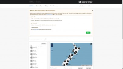
Figure 1: The NSDR web viewer, accessible from https://viewer-nsdr.landcareresearch.co.nz/
With a renewed focus on the importance of soils information and associated funding successes, the nationally significant collections and databases Land Resource Information System (LRIS) programme has been working to revitalise the NSD. Efforts have focused on two major areas: a) the design and implementation of a world-class soils observation data system able to meet today’s needs for soil data, and b) a tool for capturing new and legacy soil data.
The resulting National Soils Data Repository (NSDR) is a versatile soil observation database that now hosts the original NSD. While the original database was very specific in purpose, the NSDR database has been specifically designed to be capable of housing a variety of soil datasets that differ in content, format, and utility (such as accommodating soils sampled by depth intervals or sites resampled over time). It also comes with a dedicated authorisation and identification tool, allowing secure access for customers to see their ‘own’ datasets. The NSDR web viewer can be used for exploring publicly available soil point (profile) data across New Zealand (Fig. 1).
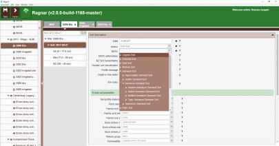
An important requirement was a computer-based data entry tool to resolve the bottleneck of getting more data into the NSDR. This tool – with a working title of ‘Ragnar’ – allows Manaaki Whenua staff to upload site and soil information directly into the NSDR database. Samples taken in the field can also be registered, and associated lab analysis results downloaded to Ragnar from the laboratory databases once they become available and linked to the related site data in the NSDR (Fig. 2).

Figure 2: Screenshot of the Data Entry Tool used by Manaaki Whenua – Landcare Research staff to facilitate data upload into the NSDR.
Ragnar is a ‘client’ application that can be installed on Windows, OS X, or Linux and provides access, over the web, to the central NSDR system. It manages access to the NSDR, allows data to be created and updated, and helps ensure the data meet appropriate rules for quality and content. Ragnar can be quickly configured to support project-specific data requirements without rewriting the application itself. It is one of several ways of interacting with the NSDR, and most importantly, is complemented by its own secure web viewer allowing access to and download of soil data sets.
Ragnar surely is a game-changer when it comes to resolving the bottleneck of soil data entry into the NSDR. In the last 12 months alone, information for more than 150 sites has been compiled, quality-checked, and entered. The focus was on upload of legacy profiles with soil water release data, and was co-funded by Canterbury, Waikato, Hawke’s Bay, Southland, and Marlborough Regional Councils, together with EnviroLink and Fertiliser Association of New Zealand. At a cost of currently at least $10,000 to characterise a new site, recovering this legacy data truly is gold for New Zealand Inc!
These new data will inform all other information products delivered through S-map, or the LRIS portal, such as the data supplied to the widely used Overseer model. Some of the data entered are from locations not yet covered in our existing soil information systems, meaning that the diversity of NZ soils will be better represented. Also, Manaaki Whenua’s efforts in the field of digital soil mapping and environmental modelling will profit from an increase in high-quality soil data.
With the NSDR up and running, and an increasing number of funders supporting our soil data compilation efforts, New Zealand is in a much stronger position to gain on-going benefits from our wide range of soil research investments, which is greatly enriching the evidence base for decision makers.
