Existing assessments of shallow landslide susceptibility in New Zealand are often qualitative and based at resolutions too low for finer-scale targeting of erosion control. Higher-resolution, quantitative, consistent estimates of shallow landslide susceptibility are needed. The acquisition of landslide data for susceptibility assessments is also a significant challenge given the size of the affected areas and the number of landslides generated, combined with the time and costs involved in mapping. Individual landslide scars are typically small (approximately 50–100 m2 in median scar size). As a result, we require high-resolution imagery to enable the accurate detection and mapping of individual landslide features for use in landslide susceptibility modelling.
We have assembled an inventory comprising over 96,000 landside scars mapped from high-resolution satellite or aerial imagery for seven study areas located across the North Island. This includes mapping using imagery acquired for storm events in the Horizons (2018), Waikato (2017), Hawke’s Bay (2011) and Greater Wellington (2005–2010) regions. We have recently acquired further satellite imagery for another four study areas in the Auckland, Waikato and Horizons regions. This new imagery will be used to augment existing landslide mapping data, thus increasing the range of terrains represented within the landslide inventory.
We are employing machine learning algorithms with data from the mapping of landslide scars and information on the landscape factors (e.g. topography, land cover, rock type) that influence landslide occurrence to predict spatial patterns in susceptibility. In contrast with previous approaches, such as ‘landslide risk’ defined within the Highly Erodible Land (HEL) map, the statistical modelling used here improves accuracy and does not assume there is no susceptibility below a pre-defined slope threshold or for areas under woody vegetation.
We have applied this approach to predict spatial patterns in shallow landslide susceptibility for the Horizons (Figure 1) and Hawke’s Bay regions.
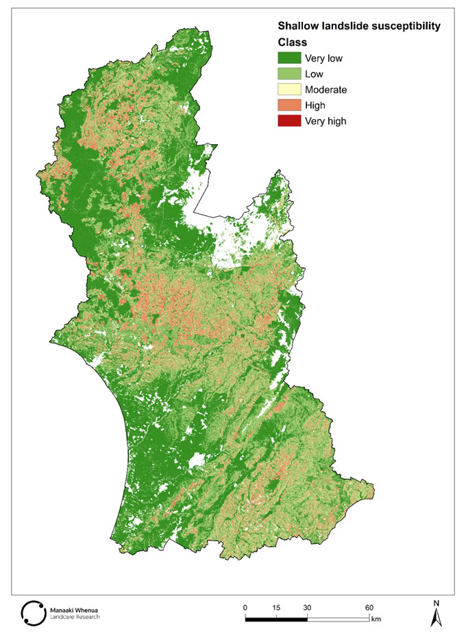
Figure 1. Shallow landslide susceptibility for the Horizons region, predicted using available data to determine the relative likelihood of landslide occurrence based on terrain and land-cover attributes. The modelled probability scale has been converted to a class-based scale for visualisation.

Other researchers