- Home
- ...
- Smarter Targeting of Erosion Control (STEC)
- Smarter Targeting of Erosion Control (STEC) News
LiDAR improves modelling of shallow landslide susceptibility for smarter targeting of erosion control

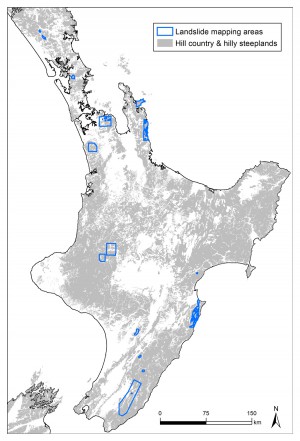
Figure 1. Study areas where shallow landslide mapping has been completed to date using high resolution (<1 m) aerial or satellite imagery.
Landslide susceptibility analysis provides a measure of the relative likelihood of a landslide occurring based on landscape conditions. Our work in the STEC programme to date has focused on assembling an inventory comprising over 100,000 landside scars mapped from high-resolution (< 1 m) satellite or aerial imagery for study areas located across the North Island (Fig. 1). The latest mapping uses very high resolution (0.5 m) imagery acquired for storm events in the Horizons (2018 storm), Waikato (2017), Auckland (2017), Hawke’s Bay (2011), and Greater Wellington (2005-2010) regions, complementing previous multi-decadal landslide mapping in the Horizons and Northland regions.
We recently completed regional-scale modelling of shallow landslide susceptibility for Hawke’s Bay1 and Horizons2. This modelling is based on the national 15- m Digital Elevation Model (DEM) and employs machine learning algorithms with landslide mapping data and information on landscape factors (e.g. topographic, land cover, rock type) that influence landslide occurrence to predict spatial patterns in susceptibility. The research underpinning the regional modelling has been submitted to an international journal for peer-review3.
With the rollout of regional Light Detection and Ranging (LiDAR) surveys, there is now opportunity to test the use of LiDAR-derived DEMs in our shallow landslide susceptibility models and compare model performance with results based on the national 15-m DEM. Recent shallow landslide mapping in the Wairarapa (Fig. 1), completed as part of Raphael Spiekermann’s PhD within the STEC programme, identified over 40,000 landslides from the 843 km2 study area4. LiDAR data are available across the Greater Wellington Region.
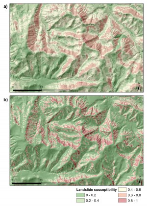
We compared performance of a logistic regression model of shallow landslide susceptibility based on the national 15- m DEM versus a 5-m LiDAR-derived DEM for the Wairarapa study area. Other spatial inputs to the model include land cover (LCDB) and rock type (NZ LRI).

Figure 2. Comparison of shallow landslide susceptibility based on a logistic regression model using a) national 15-m DEM versus b) 5-m LiDAR-derived DEM for a selected focus area within the Wairarapa study area.
Use of the LiDAR-based DEM significantly improved the model’s ability to correctly classify landslide versus non-landslide locations. Average classification accuracy increased from 72% to 88% for the 15-m versus 5-m DEMs, respectively. Comparing spatial predictions of shallow landslide susceptibility for a focus area showed considerable refinement in the predicted patterns of susceptibility when using the LiDAR-based DEM compared with the 15-m DEM (Fig. 2).
This comparison of model results demonstrates the value of higher resolution topographic data for modelling landslide susceptibility that can be used to support better targeting of erosion control.
Further information
1Smith HG 2020. A region-wide assessment of shallow landslide susceptibility in Hawke’s Bay. Landcare Research Contract Report LC3720 for Hawke’s Bay Regional Council
2Smith HG, Spiekermann R, Betts R, Neverman A 2020. Shallow landslide susceptibility analysis supports better targeting of erosion control. STEC Newsletter Issue 2, July 2020.
3Smith HG, Spiekermann R, Betts H, Neverman AJ. Comparing methods of landslide data acquisition and susceptibility modelling: examples from New Zealand. Submitted for peer-review.
4Spiekermann RI, McColl S, Fuller I, Dymond J, Burkitt L, Smith HG. Quantifying the influence of individual trees on slope stability at landscape scale. Submitted for peer-review.
Key contacts

